A .gov website belongs to an official government organization in the United States.
Secure .gov websites use HTTPS
A lock () or https:// means you've safely connected to the .gov website. Share sensitive information only on official, secure websites.
Science Introduction
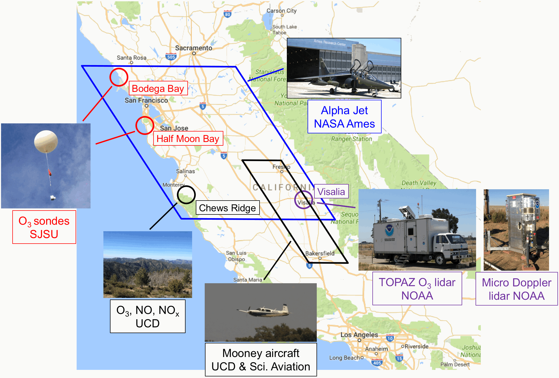
Map of central California showing instrument activities: NOAA lidar site in Visalia, SJSU ozonesonde launch sites at Bodega Bay and Half Moon Bay, UC Davis measurements at Chews Ridge, and the flight plan areas for the Mooney aircraft and the NASA Ames Alpha Jet (AJAX).
The California Baseline Ozone Transport Study (CABOTS) seeks to quantify California's starting point for complying with the federal ozone standard, by making precise ozone measurements aloft. Despite dramatic improvements in California's air quality, some areas of the state still do not meet the 2008 National Ambient Air Quality Standard (NAAQS) for 8-h average ozone of 75 parts-per-billion by volume (ppbv). This is due in part to increasing industrialization in Asia leading to higher baseline ozone concentrations entering California from the west, especially during El Niño years (e.g., 2016), resulting in higher ozone levels that cannot be reduced by the state's air quality measures. Understanding the variations in ozone entering California is becoming increasingly important as the state strives to meet the stricter ozone NAAQS of 70 ppbv, announced by the EPA in October 2015.
The CABOTS study was conducted from May through August 2016, including two intensive observational periods during the spring "transport" season, from late May to mid-June (IOP1); and during the summer "ozone" season when locally produced ozone is high, from mid-July to early August (IOP2). CABOTS involved several research groups and a number of different instruments and platforms to measure ozone and other relevant pollutants aloft.
NOAA and CIRES scientists took ozone measurements in central California using their truck-mounted Tunable Optical Profiler for Aerosol and oZone (TOPAZ) lidar, a state-of-the-art instrument for measuring ozone aloft. TOPAZ measured vertical profiles of ozone to characterize how much ozone from across the Pacific was mixed down to the surface in Visalia in central California's San Joaquin Valley. NOAA also deployed a newly developed, compact, and autonomous Doppler lidar (micro-Doppler) which measured vertical winds and atmospheric turbulence in the lowest 1-2 km above the surface.
Scientists from San Jose State University made ozonesonde measurements with technical guidance from the NOAA Global Monitoring Division. They launched balloons carrying ozonesondes that measured ozone profiles along the California coast near Bodega Bay and Half Moon Bay to characterize the ozone that entered the state from the Pacific.
Researchers from UC Davis and Scientific Aviation flew a Mooney aircraft with instruments that measured ozone and other pollutants in the southern San Joaquin Valley to study pollutant transport in the lower part of the atmosphere. UC Davis scientist also measured ozone together with other pollutants at the remote Chews Ridge site in the Central California Coastal Range.
NASA Ames scientists flew several missions with their Alpha Jet over the San Joaquin Valley and the Central California Coast. The Alpha Jet was outfitted with sensors to measure ozone and other trace gases and provided spatial coverage between the various CABOTS ground sites.