SOS 1995 Lidar Findings
Power Plant Plume Study
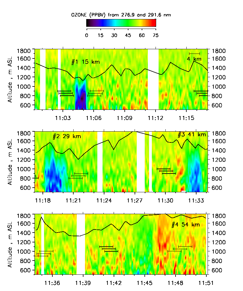
Figure 1. Data taken on 7 July 1995. Time-height cross sections of lidar ozone concentrations showing multiple crossings of the Cumberland power plant plume at different distances downwind of the plant. The boundary layer height was estimated from the lidar data and is overplotted as a black line.
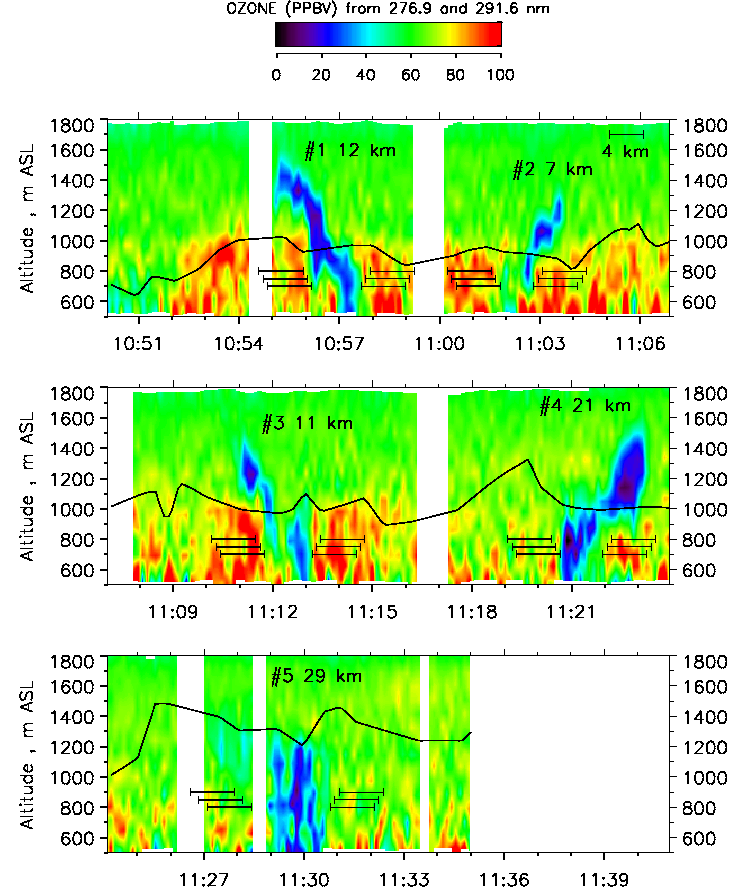
Figure 2. Data taken on 19 July 1995.
The role of airborne lidar in power plant plume studies
To investigate chemical processes in power plant plumes, airborne in situ sensors are typically the instruments of choice because of their ability to detect a multitude of chemical species with high accuracy. However, coverage of the plume area is limited, since the plume is usually only transected at a single height. This means that often assumptions must be made about plume properties when the in situ data are interpreted. An airborne lidar, on the other hand, can map out the cross section of the plume during a single overpass yielding information on plume size, shape, and the vertical distribution of certain pollutants in the plume. Thus, an airborne lidar can provide crucial information on power plant plumes properties which, in concert with in situ measurements, can help further our understanding of power plant plume chemistry and its impact on air quality.
Measurement capabilities
The airborne ozone and aerosol lidar was used to investigate power plant plumes in the Nashville area during the 1995 SOS campaign. The downward-looking lidar was typically flown at an altitude of around 3000 m above sea level crossing the power plant plume at multiple distances downwind of the plant. The aerosol backscatter and ozone data gathered while flying across the plume give a detailed picture of the vertical and lateral extent of the plume. Also, the plume location with respect to the top of the boundary layer can be determined because the lidar aerosol returns provide information on the boundary layer height. In addition, we used the lidar ozone data to calculate ozone production rates in the plume as a function of distance downwind.
Key findings
- The evolution of a power plant plume depends strongly on the local meteorological conditions. In one case study, the plume was spread quickly across the entire depth of the boundary layer due to strong vertical mixing but did not reach into the overlying free troposphere. The plume was shaped symmetrically and had a clearly defined, single core (Figure 1). In another case, part of the power plant plume had penetrated the inversion capping the boundary layer shortly after release from the stack. Subject to different meteorological conditions the two portions of the plume above and below the boundary layer top evolved differently as they advected downwind resulting in a very irregular shape and a near breakup of the plume (Figure 2).
- We found that close to the power plant ozone was destroyed creating an ozone deficit by which the plume can be readily identified. This is a well known effect caused by titration of ozone in the presence of elevated NO levels. Farther downwind, where ozone is formed in the plume due to reaction of NOx with ozone precursor gases, we observed ozone production rates of up to 4 ppbV/h. The latter confirms that NOx-rich power plant plumes have the potential of raising local ozone levels significantly over the course of a day.
More details can be found in Senff et al. (1998).