A .gov website belongs to an official government organization in the United States.
Secure .gov websites use HTTPS
A lock () or https:// means you've safely connected to the .gov website. Share sensitive information only on official, secure websites.
Postcards from the Field
Postcard from the Field: Summer Field Campaigns Take a Detailed Look at Air Quality formo Street-Level to Space. September 2023
The largest urban air quality research field campaign to date recently concluded and now the process of analyzing the mountain of data obtained is underway. The AGES+ partnership brought together scientists from NOAA, NASA, and 21 universities from three countries to deploy state-of-the-art instruments to investigate how air pollution sources in major urban cities have shifted over recent decades.
Using multiple satellites, six research aircraft, vehicles, dozens of stationary installations - even instrumented backpacks - scientists conducted detailed observations from street-level to space of air pollutants from sources including transportation, industrial facilities, agriculture, wildfires, and consumer products such as paint, pesticides, and perfumes.
The NOAA Chemical Sciences Laboratory (CSL) took the lead on three of the research projects. The largest, AEROMMA, outfitted NASA's DC-8 flying laboratory with specialized, custom-built instruments designed for measuring trace gases and particles and flew repeated, low altitude survey flights over highly populated cities, including New York City, Chicago, Detroit, Toronto, Indianapolis, and Los Angeles. Prior to the urban flights, the AEROMMA researchers spent two weeks flying over the eastern Pacific Ocean to investigate oceanic emissions that form climate-relevant sulfate aerosols and impact marine clouds.
In conjunction with AEROMMA, NASA's STAQS project deployed two Gulfstream research aircraft carrying downward-looking atmospheric composition instruments analogous to the recently launched TEMPO satellite instrument. The NOAA Twin Otter joined the other aircraft around NYC for the CUPiDS project, which focused on the boundary layer dynamics and transport that contribute to poor air quality episodes on the East Coast.
Other coordinating field projects included: joint observations by NOAA's Air Resources Laboratory and the University of Maryland of greenhouse gas and air pollution emissions in the Northeast corridor from DC to NYC; street-level measurements of ozone and PM2.5 in Manhattan aimed at investigating air pollution exposure in economically disparate neighborhoods; and a network of ground sites around NYC, Long Island, Chicago, and Toronto to provide the surface measurements that the aircraft can't reach. Major funding for the NYC-area ground sites was provided by NOAA's Climate Program Office Atmospheric Chemistry, Carbon Cycle, and Climate (AC4) program.
The data obtained this summer will go towards improving air pollution forecasts and informing decisions about the most effective ways to reduce air pollution. The data will also be used to evaluate the first observations made by NASA's TEMPO instrument, the first geostationary space-borne sensor to continuously measure air pollution across North America. Lessons learned will aid the development of NOAA's planned GeoXO satellite constellation. NOAA NESDIS was a major funding partner supporting the AEROMMA measurements and their application to these satellite capabilities.
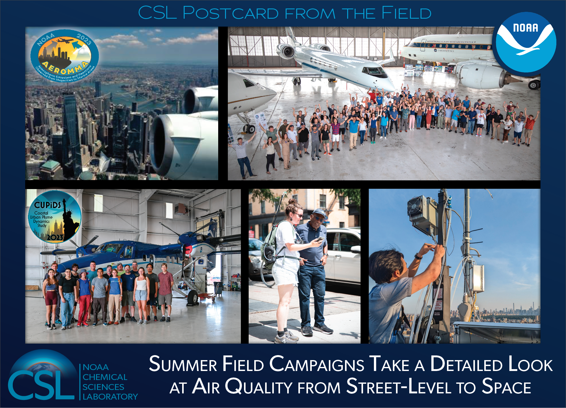
Top left: View of New York City from on-board the NASA DC-8 during NOAA's AEROMMA campaign.
Top right: Group photo of the AEROMMA and STAQS campaign participants in front of the NASA DC-8 (AEROMMA) and the two NASA Gulfstreams (STAQS) taken while on deployment at Wright-Patterson Air Force Base, Dayton, Ohio.
Bottom left: Group photo of the NOAA CUPiDS participants in front of the NOAA Twin Otter during instrument installation in Broomfield, Colorado.
Bottom middle: NOAA CSL/CIRES research scientist Audrey Gaudel explains her street-level air quality measurements to NBC's Al Roker in downtown New York City.
Bottom right: An AGES+ collaborator works on instruments at a building-top ground site at City University of New York (CUNY) in Manhattan.
Postcard from the Field: CSL's SABRE Mission Gets Airborne in Alaska to Study the Polar Stratosphere. 18 May 2023
The first series of research flights under NOAA CSL's airborne science mission to the stratosphere was completed in March, and analysis is now underway on an unprecedented data set detailing the composition and chemistry of the mid-latitude and polar stratosphere.
The overall mission, known as SABRE (Stratospheric Aerosol Processes, Budget, and Radiative Effects), is making use of one of NASA's WB-57 high altitude research aircraft to collect the most detailed measurements to date of gases and aerosols in the stratosphere. The motivation behind SABRE, the flagship field campaign of NOAA's Earth's Radiation Budget (ERB) research program, is to improve our fundamental understanding of the chemical composition of the stratosphere and the processes that govern it.
Of particular importance to this project is understanding how natural events (e.g., volcanic eruptions and wildfire pyrocumulonimbus) and human-caused emissions (e.g., rocket exhaust) perturb stratospheric aerosol composition, microphysics and radiative properties, which in turn can have significant impacts on stratospheric ozone chemistry and our global climate. Understanding the current state of our stratosphere is especially critical for evaluating how the stratosphere will respond to direct injection of sulfate aerosol, which is proposed as a method of solar radiation management or climate intervention.
This first deployment, dubbed "Cold SABRE", operated out of Eielson Air Force Base in Fairbanks, Alaska. Twelve research flights (from Alaska–there were also the two transits each direction and three science flights from Houston) were conducted from late February through late March, probing the very well-aged air of the polar stratosphere and polar vortex. The aircraft carried 17 state-of-the-art instruments, several of which were designed and custom-built at CSL, to measure ozone, water vapor, SO2, NOx, chlorine and bromine gases, black carbon, aerosol size distributions, and aerosol chemical composition. The new technologies and advanced instrumentation on-board the aircraft for SABRE are able to make measurements at much lower levels than was possible on past missions and to make new measurements of chemicals that have never been directly measured in the stratosphere.
SABRE is a NOAA Earth's Radiation Budget (ERB) Initiative project. Learn more about SABRE.
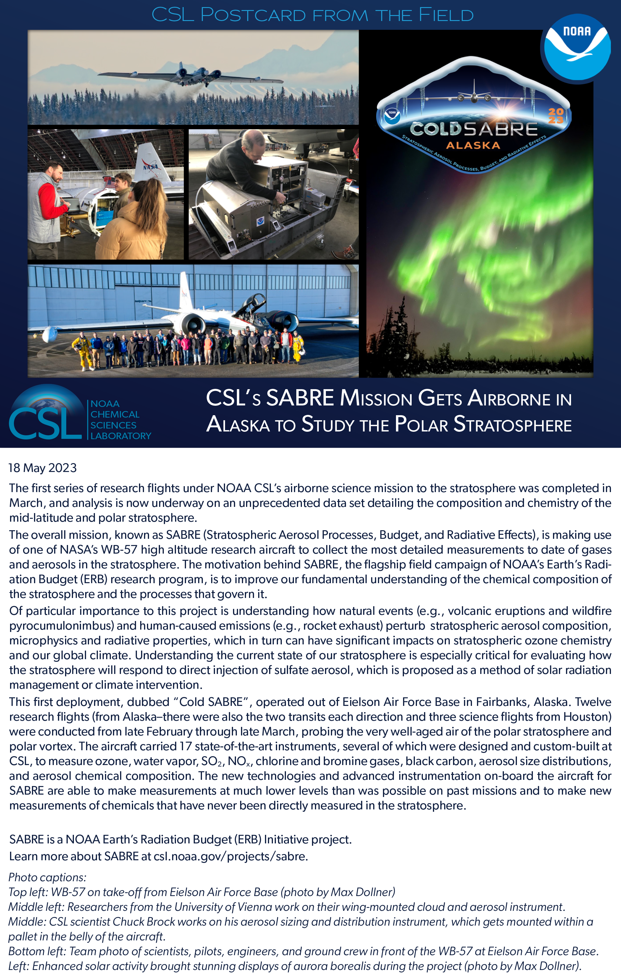
Top left: WB-57 on take-off from Eielson Air Force Base (photo by Max Dollner).
Middle left: Researchers from the University of Vienna work on their wing-mounted cloud and aerosol instrument.
Middle: CSL scientist Chuck Brock works on his aerosol sizing and distribution instrument, which gets mounted within a
pallet in the belly of the aircraft.
Bottom left: Team photo of scientists, pilots, engineers, and ground crew in front of the WB-57 at Eielson Air Force Base.
Left: Enhanced solar activity brought stunning displays of aurora borealis during the project (photo by Max Dollner).
Postcard from the Field: From the Ground to the Air, CSL Scientists get an up close look at Dynamics and Emissions from Western Wildfires. 13 September 2022
Scientists from NOAA's Chemical Sciences Laboratory and the University of Colorado CIRES are in California this summer, partnering with San Jose State University and the University of Nevada, Reno for a five-week study of wildfires and their response to evolving wind fields in the complex terrain of the Western US. The mission, called CalFiDE (California Fire Dynamics Experiment), combines aircraft and ground-based mobile remote-sensing and in situ measurements for a comprehensive and detailed look at fire behavior, plume dynamics, and emissions. Since late August, scientists have studied several wildfires in Northern California and Oregon, including, most recently, the Mosquito Fire in Placer County, CA, which grew significantly in size late last week, exhibiting extreme fire behavior and generating massive pyrocumulous.
For the airborne measurements, a NOAA Twin Otter is outfitted with instruments to measure a suite of atmospheric chemistry compounds as well as a scanning Doppler lidar to measure vertical and horizontal winds over and around wildfires. The aircraft also carries a high-resolution infrared imaging system to track the evolution of the active flame front and other sensors to measure fire radiative power (FRP). On the ground, CSL's PUMAS (Pickup-based Mobile Atmospheric Sounder) truck is deployed with mobile Doppler lidar and radar systems from our California and Nevada partners. The combined measurements will provide new information on how spatially complex and temporally evolving inflow wind fields impact fire behavior and plume dynamics This experiment will also provide new data on the emissions and chemistry leading to ozone formation and particulates in wildfire plumes, which will help advance our understanding of the significant air quality impacts affecting populated areas downwind of these plumes.
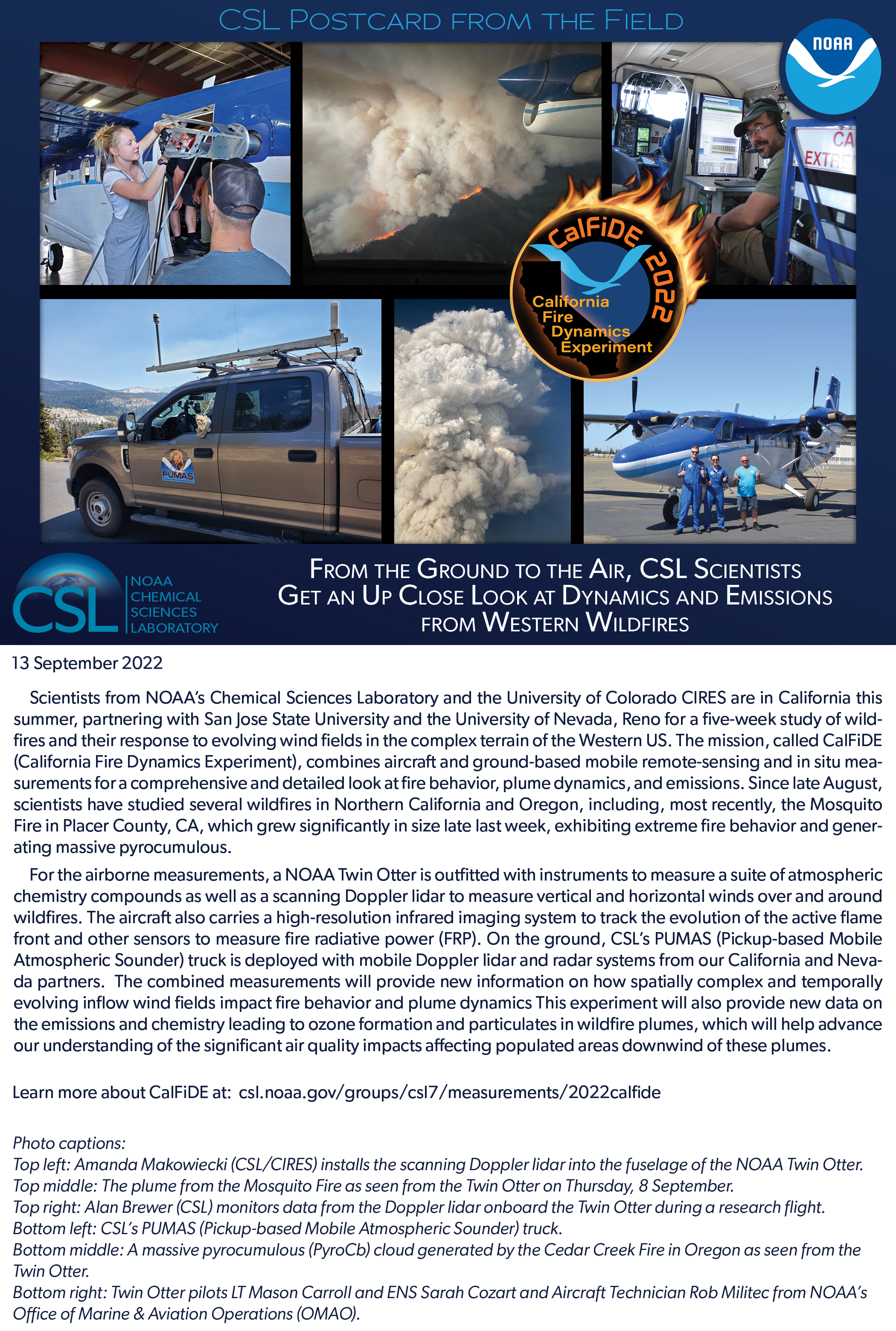
Top left: Amanda Makowiecki (NOAA/CIRES) installs the scanning Doppler lidar into the fuselage of the NOAA Twin Otter. Top middle: The plume from the Mosquito Fire as seen from the Twin Otter on Thursday, 8 September.
Top right: Alan Brewer (NOAA) monitors data from the Doppler lidar onboard the Twin Otter during a research flight. Bottom left: CSL's PUMAS (Pickup-based Mobile Atmospheric Sounder) truck.
Bottom middle: A massive pyrocumulous (PyroCb) cloud generated by the Cedar Creek Fire in Oregon as seen from the Twin Otter.
Bottom right: Twin Otter pilots LT Mason Carroll and ENS Sarah Cozart and Aircraft Technician Rob Militec from NOAA's Office of Marine & Aviation Operations (OMAO).
Postcard from the Field: A rare opportunity to study emissions. 25 April 2022
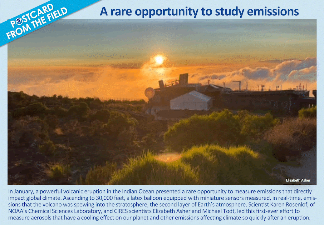
Shown is a giant balloon sent aloft in the Indian Ocean where, in January, a powerful volcanic eruption presented a rare opportunity to measure emissions that directly impact global climate. Ascending to 30,000 feet, the latex balloon equipped with miniature sensors measured, in real-time, emissions that the volcano was spewing into the stratosphere, the second layer of Earth's atmosphere. Scientist Karen Rosenlof, of NOAA's Chemical Sciences Laboratory, and CIRES scientists Elizabeth Asher and Michael Todt, led this first-ever effort to measure aerosols that have a cooling effect on our planet and other emissions affecting climate so quickly after an eruption.
Postcard from the Field: CSL Researchers in La Réunion to Study the Stratospheric Plume from the Tonga Eruption. 3 March 2022
The eruptions of the Hunga Tonga–Hunga Ha'apai (HTHH) volcano on 13 and 15 January in the southwest Pacific injected ash, sulfur dioxide (SO2), and water vapor into the stratosphere to altitudes exceeding 30 km. This eruption provided the rare opportunity to study the microphysical processes that occur when SO2 gas is emitted into the stratosphere immediately following a volcanic eruption. Volcanic emissions are an important aspect of our climate system since the stratospheric sulfate aerosols produced by volcanoes are the major source of stratospheric aerosols and large volcanic eruptions (such as Mt. Pinatubo in 1991) are known to cause global-scale cooling effects on our climate. The SO2 mass injected into the stratosphere from the HTHH volcano is estimated to be ~1-2% of that from Mt. Pinatubo and is unlikely to produce a measurable global cooling.
To take advantage of this opportunity, CIRES scientists from NOAA CSL and colleagues from the University of Houston and St. Edwards University arrived at La Réunion, an island in the Indian Ocean, 6 days after the eruption on 21 January and immediately began making in situ chemical measurements of the volcanic plume using balloonsondes that can rise to 30 km altitude. Measurements of aerosols, SO2, water vapor, and ozone were conducted during a 5 day intensive period at the high altitude Maïdo Atmospheric Observatory operated by LACy, OSUR, and CNRS/Université de la Réunion/Météo-France. An international group of satellite and modeling experts supported the intensive period with weather and aerosol forecasts.
Analysis of the data collected is now underway, and colleagues at Maïdo Observatory will continue to launch balloons over the course of months to observe the plume evolution. The measurements from TR2Ex will be valuable for improving the accuracy and predictive capabilities of aerosol processes in climate models.
TR2Ex is an Intensive Operating Period (IOP) of the Balloon Baseline Stratospheric Aerosol Profiles (B2SAP) project.
B2SAP is a NOAA Earth's Radiation Budget (ERB) Initiative project. Learn more about TR2Ex.
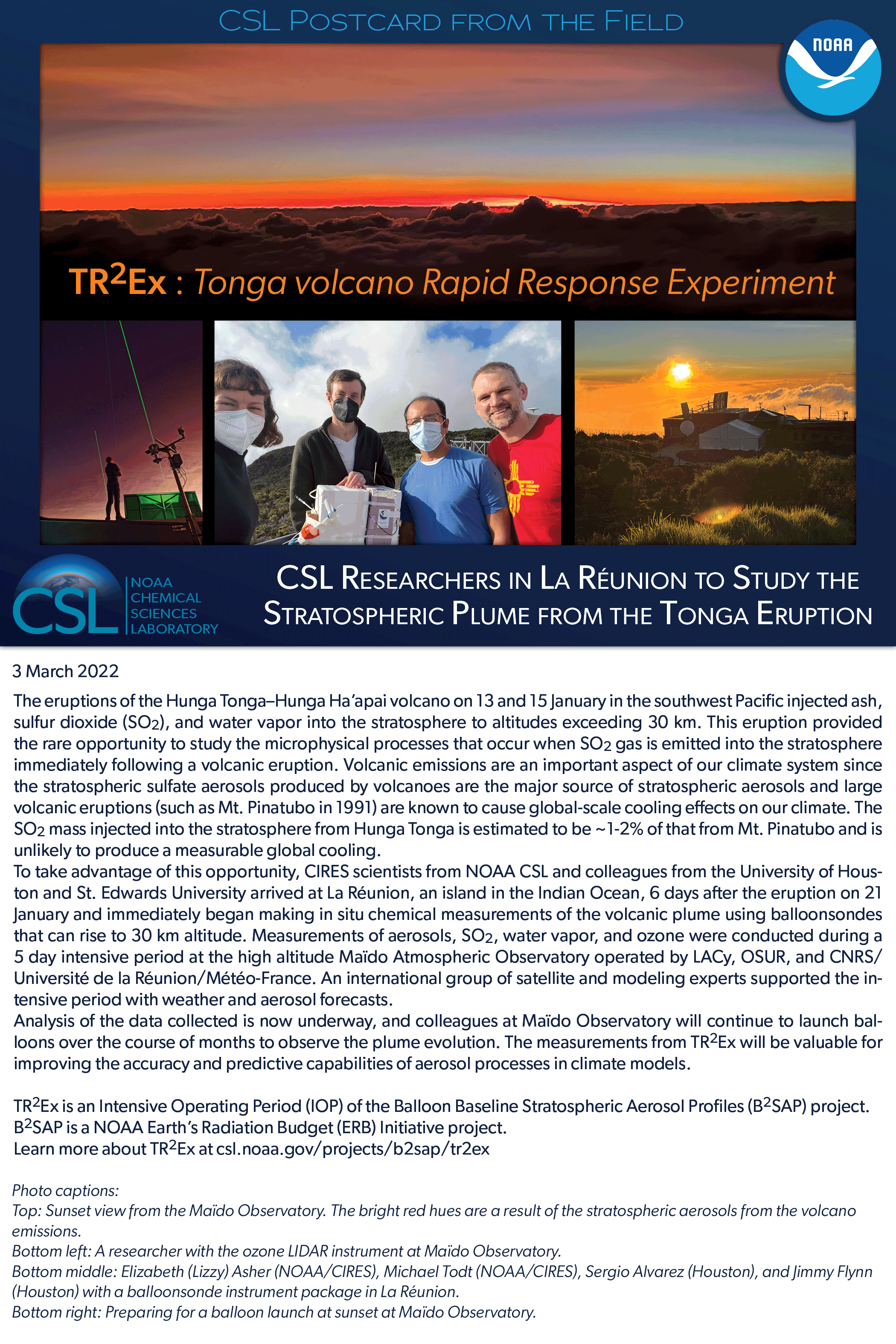
Top: Sunset view from the Maïdo Observatory. The bright red hues are a result of the stratospheric aerosols from the volcano emissions.
Bottom left: A researcher with the ozone LIDAR instrument at Maïdo Observatory.
Bottom middle: Elizabeth (Lizzy) Asher (NOAA/CIRES), Michael Todt (NOAA/CIRES), Sergio Alvarez (Houston), and Jimmy Flynn (Houston) with a balloonsonde instrument package in La Réunion.
Bottom right: Preparing for a balloon launch at sunset at Maïdo Observatory.
Postcard from the Field: High Altitude Test Flights Begin for NOAA CSL's SABRE Mission in Houston, Texas. 17 February 2022
Test flights for the Stratospheric Aerosol processes, Budget and Radiative Effects (SABRE) mission started this week in Houston, TX. Scientists from NOAA's Chemical Sciences Laboratory and CIRES, along with NASA and university partners, have been at Ellington Field for the past two weeks to test new atmospheric instrumentation on NASA's high-altitude WB-57 research aircraft. The test flights allow the scientists to check the performance of research instruments, many of which are newly developed or have never been flown at extremely high altitudes.
NOAA CSL's SABRE mission will study the chemistry and composition of the upper troposphere and lower stratosphere up to altitudes of 60,000 ft. The instrumentation on-board will capture real-time measurements of trace gases such as ozone and chlorine compounds, as well as the composition, microphysics, and radiative properties of aerosols. SABRE measurements will ultimately enable more accurate quantification of the direct and indirect climate impacts from variations in stratospheric aerosols and gases in the present-day atmosphere and provide a foundation for estimating changes in aerosol radiative forcing under future climate scenarios.
SABRE is a NOAA Earth's Radiation Budget (ERB) Initiative project. Learn more about SABRE.
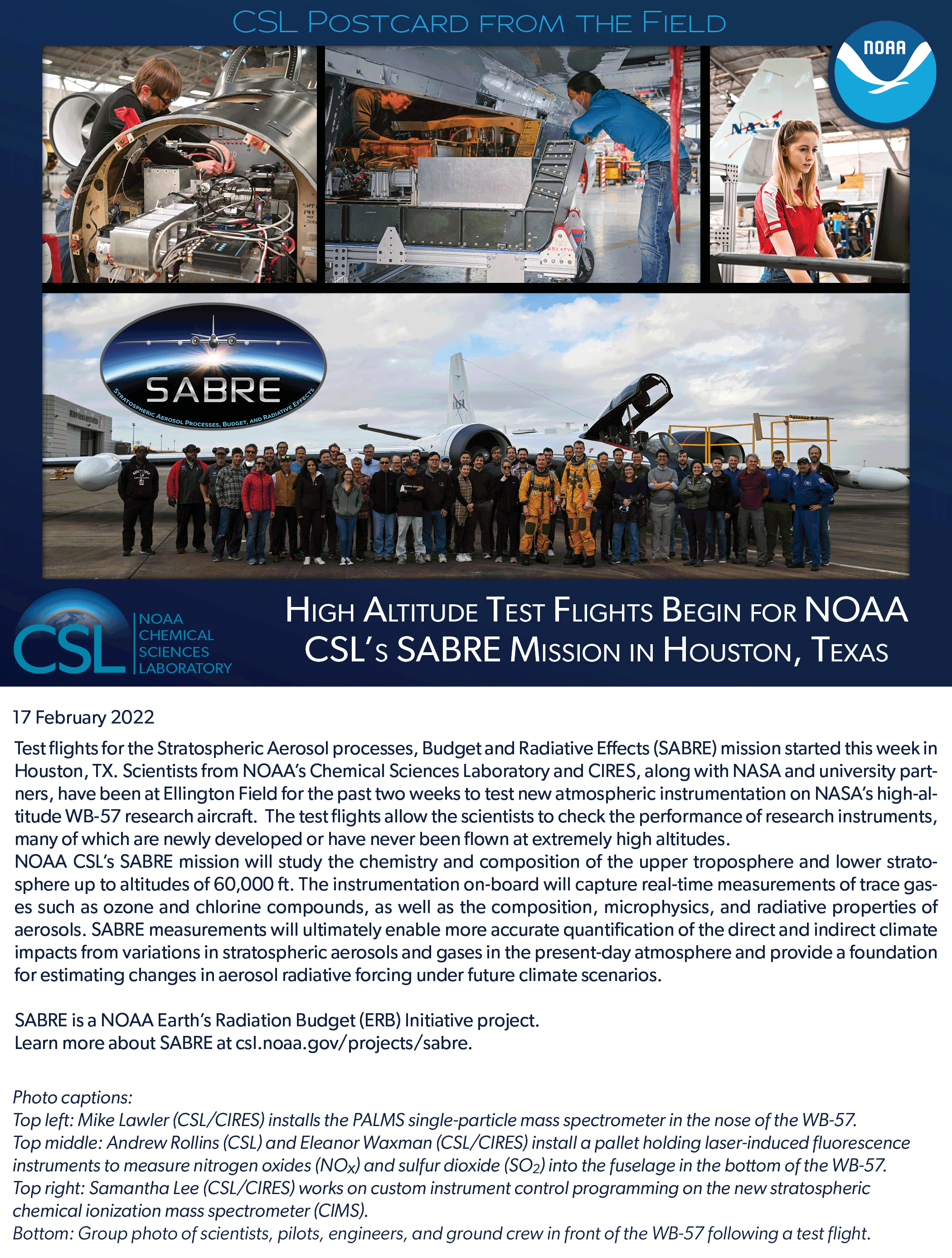
Top left: Mike Lawler (NOAA CSL / CIRES) installs the PALMS single-particle mass spectrometer in the nose of the WB-57.
Top middle: Andrew Rollins, (NOAA CSL), and Eleanor Waxman, (NOAA CSL / CIRES), install a pallet holding laser-induced fluorescence instruments to measure nitrogen oxides (NOx) and sulfur dioxide (SO2) into the fuselage in the bottom of the WB-57.
Top right: Samantha Lee, (NOAA CSL / CIRES), works on custom instrument control programming on the new stratospheric chemical ionization mass spectrometer (CIMS).
Bottom: Group photo of scientists, pilots, engineers, and ground crew in front of the WB-57 following a test flight.