Demetillo, M.A.G., A. Navarro, K.K. Knowles, K.P. Fields, J.A. Geddes, C.R. Nowlan, S.J. Janz, L.M. Judd, J. Al-Saadi, K. Sun, B.C. McDonald, G.S. Diskin, and S.E. Pusede, Observing nitrogen dioxide air pollution inequality using high-spatial-resolution remote sensing measurements in Houston, Texas, Environmental Science & Technology, doi:10.1021/acs.est.0c01864, 2020.
Abstract
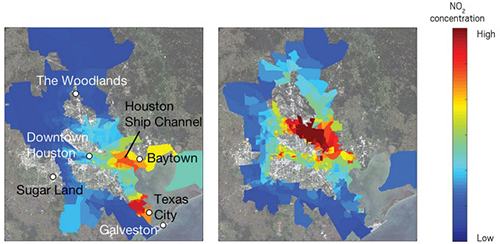
Houston, Texas is a major U.S. urban and industrial area where poor air quality is unevenly distributed, and a disproportionate share is located in low-income, non-white, and Hispanic neighborhoods. We have traditionally lacked city-wide observations to fully describe these spatial heterogeneities in Houston and in cities globally, especially for reactive gases like nitrogen dioxide (NO2). Here, we analyze novel high-spatial-resolution (250 m x 500 m) NO2 vertical columns measured by the NASA GCAS airborne spectrometer as part of the September 2013 NASA DISCOVER-AQ mission and discuss differences in population-weighted NO2 at the census-tract level. Based on the average of 35 repeated flight circuits, we find 37 ± 6% higher NO2 for non-whites and Hispanics living in low-income tracts (LIN) compared to whites living in high income tracts (HIW) and report NO2 disparities separately by race ethnicity (11−32%) and poverty status (15−28%). We observe substantial time-of-day and day-to-day variability in LIN-HIW NO2 differences (and in other metrics) driven by the greater prevalence of NOx (≡NO + NO2) emission sources in low-income, non-white, and Hispanic neighborhoods. We evaluate measurements from the recently launched satellite sensor TROPOMI (3.5 km x 7 km at nadir), averaged to 0.01° x 0.01° using physics-based oversampling, and demonstrate that TROPOMI resolves similar relative, but not absolute, tract-level differences compared to GCAS. We utilize the high-resolution FIVE and NEI NOx inventories, plus one year of TROPOMI weekday−weekend variability, to attribute tract-level NO2 disparities to industrial sources and heavy-duty diesel trucking. We show that GCAS and TROPOMI spatial patterns correspond to the surface patterns measured using aircraft profiling and surface monitors. We discuss opportunities for satellite remote sensing to inform decision making in cities generally.