A .gov website belongs to an official government organization in the United States.
Secure .gov websites use HTTPS
A lock () or https:// means you've safely connected to the .gov website. Share sensitive information only on official, secure websites.
2021 News & Events
Research suggests frigid Arctic air outbreaks may be predictable
28 January 2021 adapted from the story by NOAA Communications
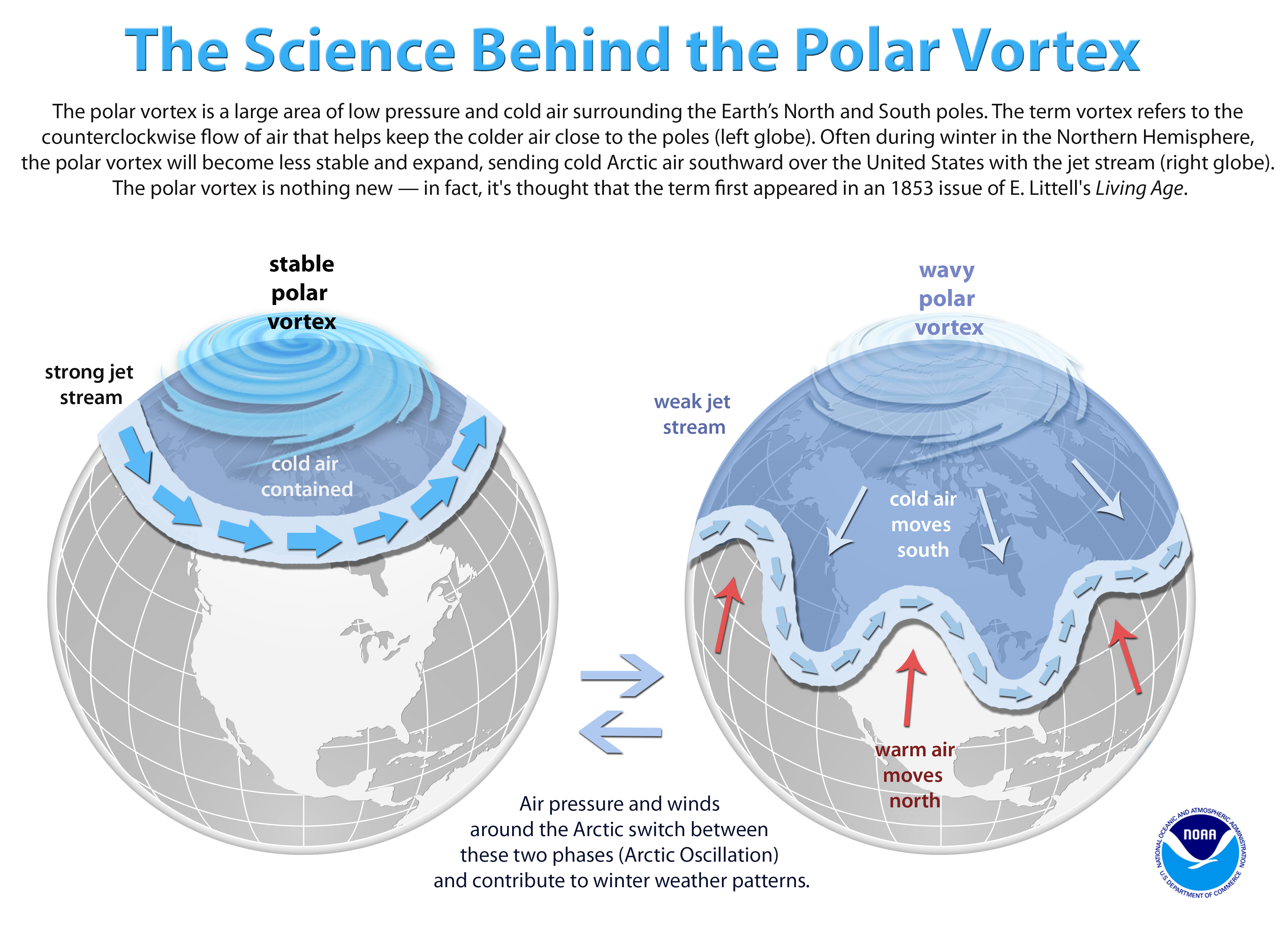
How the Arctic stratosphere influences our weather. This graphic presents the fundamental atmospheric drivers of the polar vortex. New research suggests scientists may one day be able to improve predictability of extreme weather in the mid-latitudes that result from stratospheric events which disrupt the polar vortex. Understanding the Arctic polar vortex Graphic: NOAA
There's a saying among climate scientists: What happens in the Arctic doesn't necessarily stay in the Arctic.
That's especially true when a sudden warming of the polar stratosphere – the layer of the atmosphere just above the layer where we live – in winter causes the Arctic jet stream to slow and wobble, spilling frigid air and extreme weather south over North America and Europe, often for weeks at a time. One of these sudden stratospheric warming (SSW) events recently occurred on 5 January 2021, and could influence the next several weeks of winter weather for millions of people.
In a recent paper published in Communications Earth and Environment, NOAA CSL scientist Amy Butler and her colleague, Daniela Domeisen, a scientist with Switzerland's Institute for Atmospheric and Climate Science at ETH Zurich, argue that a better understanding of how the stratosphere influences the troposphere, or lowest level of the atmosphere where we live, along with improved numerical weather models, could one day help scientists better predict the type, magnitude, frequency and location of extreme events from weeks to months ahead of time.
SSWs are well-known for increasing the likelihood of cold extremes over the eastern U.S. and northern Europe and Asia. Scientists estimate that the stratosphere is responsible for around 10 percent of our winter weather.
"In our study, we show that the impacts from these events are more wide-ranging, and could have significant impacts on weather extremes globally beyond cold events," Butler said. "There are indications that SSWs could lead to repetitive landfalling storm systems over southern Europe, increased risk of flooding in the Mediterranean, and winter heat extremes in the Canadian Arctic and Middle East."
One recent example occurred in February 2020, when a train of severe storms that battered England caused heavy flooding. "It was remarkable that the storms all followed the same path," Domeisen said. "The polar vortex was unusually strong during that period, which allowed it to stabilize the path of the storms. Typically, storm tracks will frequently shift, but in this case, storms kept following the same path."
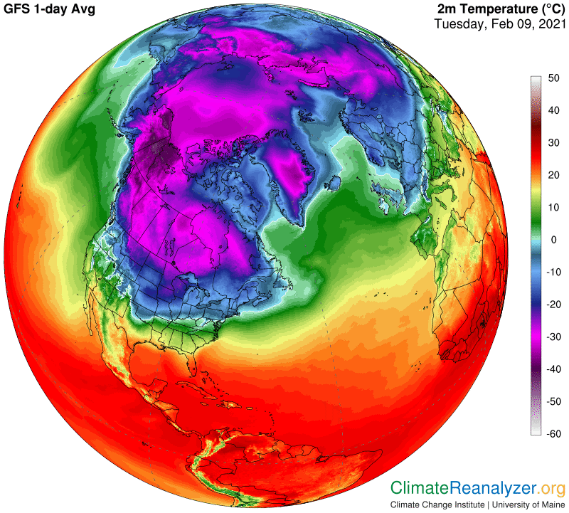
Arctic air spills into the United States following a disruption of the stratospheric polar vortex on 5 January 2021. Map: ClimateReanalyzer.org
Tough to predict
Despite significant improvements in weather forecasting in recent decades, meteorologists still struggle to predict the severity of weather events more than a few days ahead of time. SSW effects can last for weeks, Butler said, which increases the probability that associated extreme weather conditions will occur beyond a typical 7-day weather forecast.
"While in many ways, we are only in the early days of understanding how the stratosphere contributes to weather extremes and their predictability, the inherent chaos of the atmosphere means realistically there will never be a point where we could say something like "three weeks from now New York City will see a two-foot snowfall," she said.
However, since the stratospheric polar vortex takes a long time to recover after these events, its effects can last for weeks afterwards. With more research, scientists may be able to calculate the chance that weather patterns associated with SSWs will occur weeks ahead of time.
"If we can identify shifts in the likelihood of weather conditions following a SSW, that would provide more lead time for preparation and response to extreme weather that follows," Butler said.
The stratosphere, the layer of the atmosphere at heights between 10-50 km, is an important source of variability for the weather and climate at the Earth's surface on timescales of weeks to decades. Since the stratospheric circulation evolves more slowly than that of the troposphere below, it can contribute to predictability at the surface. Our synthesis of studies on the coupling between the stratosphere and the troposphere reveals that the stratosphere also contributes substantially to a wide range of climate-related extreme events. These extreme events include cold air outbreaks and extreme heat, air pollution, wildfires, wind extremes, and storm clusters, as well as changes in tropical cyclones and sea ice cover, and they can have devastating consequences for human health, infrastructure, and ecosystems. A better understanding of the vertical coupling in the atmosphere, along with improved representation in numerical models, is therefore expected to help predict extreme events on timescales from weeks to decades in terms of the event type, magnitude, frequency, location, and timing. With a better understanding of stratosphere-troposphere coupling, it may be possible to link more tropospheric extremes to stratospheric forcing, which will be crucial for emergency planning and management.