Chemistry & Climate Processes: Products

SWOOSH: Stratospheric Water and OzOne Satellite Homogenized data set

water vapor tape recorder timeseries
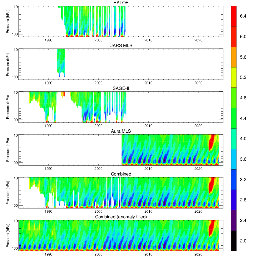
A timeseries of the 20°S-20°N average water vapor concentration, the so-called "water vapor tape recorder." The top 4 panels show the tape recorder signal from individual satellite instruments. The bottom two panels show the combined product (next to bottom) and the combined+filled product (bottom).

The Stratospheric Water and OzOne Satellite Homogenized (SWOOSH) data set is a merged record of stratospheric ozone and water vapor measurements taken by a number of limb sounding and solar occultation satellites over the previous ~40 years (1984 to present). SWOOSH version 2.6 includes data from SAGE-II/III, UARS HALOE, UARS MLS, and Aura MLS instruments. Version 2.7 includes data from these instruments plus ACE-FTS, OMPS-LP, and SAGE III/ISS. The measurements are homogenized by applying corrections that are calculated from data taken during time periods of instrument overlap.

The primary SWOOSH data product consists of monthly-mean zonal-mean values on a pressure grid. In addition to the primary (zonal-mean) grid, SWOOSH data are also available on 3D (longitude/latitude/pressure), equivalent latitude, and isentropic grids.

The gridded data include the mean, standard deviation, number of observations, and mean uncertainty from each instrument. Also included is a merged (multi-instrument) product based on a weighted mean of the available measurements. Because the merged product contains missing data, a merged and filled product is also provided for (e.g., modeling) studies requiring a continuous dataset.

Point of Contact: Sean Davis, NOAA

Publications

Publications using SWOOSH

Data Access


Data Use Policy

These SWOOSH data are made freely available to the public and the scientific community, and are the product of extensive research and effort to maintain and improve their accuracy and quality. However, the availability of these data does not constitute publication, and NOAA Chemical Sciences Division (CSD) and their collaborating partners require citable outputs from their research to ensure its continued support. We therefore expect all users of this data to ensure that the responsible scientists receive fair credit for their work, and are offered the opportunity to contribute to the research uses of the data as they deem appropriate.

Accordingly, we ask that all users note and adhere to the following guidelines and procedures when using these data:

  1. These data are freely available for exploratory analysis. At such time as a journal publication or conference presentation is planned using these data, the PIs (Sean Davis and Karen Rosenlof) should be informed of the nature and aims of the research project and the intended use of the data.
  2. Contacting the PIs will ensure they have adequate foreknowledge of the proposed research and thus the opportunity to contribute as appropriate to the use of SWOOSH data in the proposed research project.
  3. If the PI makes a significant intellectual contribution to the research, or if the data are essential to the work, or if an important result or conclusion depends on the data, co−authorship would normally be expected. This should be discussed at an early stage in the work.
  4. Manuscripts using the data with NOAA co−authors should be sent to the coauthors for review well before (e.g. 4 weeks) they are submitted for publication, to ensure that the quality and limitations of the data are accurately represented and the coauthors have adequate time to provide input.
  5. Cite this data set when used as a source: Davis, S. M., Rosenlof, K. H., Hassler, B., Hurst, D. F., Read, W. G., Vömel, H., Selkirk, H., Fujiwara, M., and Damadeo, R.: The Stratospheric Water and Ozone Satellite Homogenized (SWOOSH) database: A long-term database for climate studies, Earth System Science Data, doi:10.5194/essd-8-461-2016, 2016.

  Please check this box to signify acknowledgement of our data policy and access this data set.


Documentation

SWOOSH User's Guide

If you use this data set for a publication, please cite: Davis, S. M., Rosenlof, K. H., Hassler, B., Hurst, D. F., Read, W. G., Vömel, H., Selkirk, H., Fujiwara, M., and Damadeo, R.: The Stratospheric Water and Ozone Satellite Homogenized (SWOOSH) database: A long-term database for climate studies, Earth System Science Data, doi:10.5194/essd-8-461-2016, 2016.

Browse Data

Three plot types are available. Select a value from each menu following a chosen plot type to browse that data.

Timeseries plots on pressure levels:

Planview plots (latitude vs. time):

Cross-section plots (latitude vs. height):