Chemistry & Climate Processes: Projects

Members of the Chemistry & Climate Processes group have been involved in a number of aircraft-based field campaigns led by NOAA, NASA and NCAR. Involvement has included mission leadership roles, operational flight planning, ancillary data production, modeling and analysis. Operational flight planning has been enhanced through development of an in house flight planning tool that has been progressively improved since the mid 1990s and has been used extensively.

Field Campaigns

SABRE, Ellington Field. Stratospheric aerosols are an important component of Earth's albedo, and therefore energy balance, and provide surface area for heterogeneous chemistry, which can lead to stratospheric ozone loss. Acquiring a comprehensive database of stratospheric aerosol, trace gas and dynamical observations to establish the baseline state and background variability of the stratosphere is essential. CSL integrates instruments aboard the the NASA WB-57 research aircraft. Test flights commence from Ellington Field, Houston, Texas in January 2022. An Arctic deployment occurs February-March 2023, followed by tropical science Summer 2025 and southern hemisphere science Summer 2026. More Info

SABRE logo

ACCLIP, South Korea. The Asian Summer Monsoon Chemical & CLimate Impact Project (ACCLIP) will deploy from Osan Air Base in South Korea the Summer of 2022. The Asian Summer Monsoon (ASM) is the largest meteorological pattern in the Northern Hemisphere (NH) summer season. Persistent convection and the large anticyclonic flow pattern in the upper troposphere and lower stratosphere (UT/LS) associated with ASM leads to a significant enhancement in the UT/LS of trace species from pollution and biomass burning origins. The monsoon convection occurs over South, Southeast, and East Asia, a region of uniquely complex and rapidly changing emissions tied to both its high population density and significant economic growth. The coupling of the most polluted boundary layer on Earth to the largest dynamical system in the summer season through the deep monsoon convection has the potential to create significant chemical and climate impacts. An accurate representation of the ASM transport, chemical and microphysical processes in chemistry-climate models is much needed for characterizing ASM chemistry-climate interactions and for predicting its future impact in a changing climate. CSL integrates instruments aboard the the NASA WB-57 research aircraft. Test flights commence from Ellington Field, Houston, Texas in Summer 2021. More Info

ACCLIP logo

B2SAP, global. The Balloon Baseline Stratospheric Aerosol Profiles (B2SAP) measurement program is a NOAA CSL and GML led effort in collaboration with university and international colleagues to provide balloon-borne ozone, water vapor, aerosol, and aerosol optical depth profiles, compiled to characterize the background state and variability of radiatively important aerosols, water vapor, and ozone in Earth's stratosphere. Intensive operating periods occur over a five year period, including a rare opportunity in January 2022 to make in situ measurements of volcanic aerosols. More Info

red color of volcanic aerosols in La RĂ©union sunrise
red color of volcanic aerosols in La Réunion sunrise

Stratéole-2, Seychelles. Stratéole-2 is a long duration super-pressure ballooning project to study the tropical tropopause layer. The project is led by CNES and LMD in France and includes researchers in the United States funded by the National Science Foundation as well as partners from several other countries. CSL and GML researchers have been involved in the development and deployment of the balloon instrumentation, and have been involved in scientific planning, validation, and analysis activities related to the project. The team will launch dozens of super pressure balloons capable of staying aloft for over 3 months at altitudes of 18 to 20 km over the course of three field campaigns. The Stratéole-2 engineering campaign took place from October 2019 through March 2020, and the first science campaign is scheduled for winter 2021-2022. More Info

Strateole-2 logo

FIREX-AQ, Western U.S. Fire Influence on Regional to Global Environments and Air Quality (FIREX-AQ) is a NOAA / NASA interagency intensive study of North American fires during the 2019 wildfire season. The project combines the previously separate NASA FIREChem and NOAA FIREX aircraft campaigns to better study the atmospheric effects of wildland and agricultural fires in the U.S. This offers significant advantages to the research community by optimally leveraging the scientific interests, personnel, and assets of NASA, NOAA, other agencies, and academic partners in a fully integrated program of field measurements, modeling, and interpretation. More Info

FIREX-AQ logo

POSIDON, Guam. The Pacific Oxidants, Sulfur, Ice, Dehydration, and cONvection (POSIDON) Experiment is a focused airborne science mission to study the ozone distribution, sulfur chemistry, very short-lived ozone depleting species (VSLS), cloud microphysics, and dehydration in the tropical upper troposphere and lower stratosphere over the western Pacific. Instrumentation aboard the NASA WB-57F deploys in the fall 2016 to Guam. CSD and GMD federal and cooperative institute (CIRES) researchers and engineers have designed, built, and installed five of the 12 instruments and all of the balloon packages. Flight planning and meteorology/forecasting products provided by NASA and CSD. More Info

POSIDON logo

ATom, global. The Atmospheric Tomography Mission (ATom) studies the impact of human-produced air pollution on greenhouse gases and on chemically reactive gases in the atmosphere. Airborne instruments look at how atmospheric chemistry is transformed by various air pollutants and at the impact on methane and ozone which affect climate. Observations occur seasonally over three years (2016-2018). Flights aboard NASA's DC-8 originate from the NASA Armstrong Flight Research Center in Palmdale, California, fly north to the western Arctic, south to the South Pacific, east to the Atlantic, north to Greenland, and return to California across central North America for a systematic, global-scale sampling of the atmosphere. More Info

ATom logo

AeroMarine, La Réunion. The AeroMarine project was an international collaborative effort between NOAA (USA) and OSU-Réunion and LACy laboratory (France). The Southern Indian Ocean is potentially a hot spot for sea spray emission due to strong trade winds and high sea surface temperature. Hence, measurements taken from La Réunion are relevant for several topics related to marine aerosols and pristine oceanic regions. CSD deployed the POPS (Printed Optical Particle Spectrometer) instrument to La Réunion to observe marine aerosols during a two week field campaign in March 2016. More Info

ULA flight directed by Jerome Brioude
POPS on ultra light aircraft flown from La Réunion

VIRGAS, Houston, Texas. The Volcano-plume Investigation Readiness and Gas-phase and Aerosol Sulfur (VIRGAS) field experiment in October 2015 helps to characterize the stratospheric sulfate aerosol layer in a non-volcanic time period, and test the possibility of a new standing capability for measuring SO2, other gases, and particles in the plumes from volcanic eruptions. Partnering with NOAA, NASA would deploy the WB-57F research aircraft soon after future volcanic eruptions, giving scientists an unprecedented opportunity to observe the volcanic plume and understand the implications for climate and the atmosphere. More Info

NASA WB-57
NASA WB-57 high-altitude research aircraft

Balloon Borne Fiber Optic Temperature Profiler Sensor project. This project seeks to demonstrate the capabilities of a fiber-optic temperature profiler instrument for use aboard a drifting high altitude balloon platform, with the ultimate goal of enabling high vertical resolution temperature measurements within the Tropical Tropopause Layer. These measurements make a significant contribution to our understanding of stratospheric dynamics and composition, which are both important for understanding climate variability and climate change. Testing this new instrument has been funded by a CIRES Innovative Research Program grant, and is joint with CU-LASP and Edge of Space Sciences (EOSS); a Denver, Colorado based non-profit organization that promotes science and education by exploring frontiers in amateur radio and high altitude balloons. The goal is to eventually fly this instrument on the Strateole-2 Campaign on Science of the Equatorial Upper Troposphere/Lower Stratosphere during 2017/2018. More Info

fiber optic temperature profiler launch
EOSS 204 fiber-optic temperature profiler launch 7 March 2015

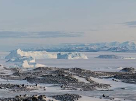
2ODIAC, Antarctica. The 2-season Ozone Depletion and Interaction with Aerosols Campaign (2ODIAC) is the first simultaneous high-resolution measurements of the physics and chemistry of aerosols (fine particles in the atmosphere) and trace gasses (such as ozone) in Antarctica. 2ODIAC provides the most detailed observations of naturally occurring aerosols and trace gases ever made in Antarctica. By using state of the art instrumentation for the first time in Antarctica, we are able to answer questions about the composition, sizes and chemistry of these fine particles, the natural and man made sources of these particles, their interactions with gases, snow, and ice, and how they evolve between the dark, sunless winters and the perpetual daylight of summer. These data are fundamental to understanding the role of aerosol particles in the pristine environment of Antarctica. Scientists involved are from the University of Colorado (LASP and CIRES), Drexel University, and the University of Wyoming. More Info

icebergs near field site
Grounded icebergs near Antarctica field site

NOAA SEED project. The NOAA Special Early-Stage Experimental or Developmental (SEED) project conducted the very first test flights for new instruments designed to measure properties and climate effects of airborne fine particles (aerosols) using the Manta Unmanned Aircraft System (UAS). CSD developed two new instruments for the Manta, the Printed Optical Particle Spectrometer (POPS) and an upward-looking radiometer (ULR), filling key measurement gaps in the payload. They contribute to a potentially powerful new tool for NOAA to address climate and air quality issues related to aerosols in remote and hard-to-access regions. More Info

NOAA Manta UAS launch
NOAA Manta Unmanned Aircraft System (UAS) launch

SEAC4RS, Houston, Texas. Studies of Emissions and Atmospheric Composition, Clouds and Climate Coupling by Regional Surveys (SEAC4RS) is based out of Ellington Field in August - September 2013. Focused on pollution emissions and the evolution of gases and aerosols in deep convective outflow, and the influences and feedbacks of aerosol particles from anthropogenic pollution and biomass burning on meteorology and climate, the project requires two aircraft to accomplish the goals. The NASA DC-8 provides observations from near the surface to 12 km, and the NASA ER-2 provides high altitude observations reaching into the lower stratosphere as well as important remote sensing observations connecting satellites with observations from lower flying aircraft and surface sites. More Info

SEAC4RS logo

ATTREX, Palmdale, California and Guam. Airborne Tropical Tropopause Experiment (ATTREX) is a series of measurement campaigns (September - November 2011, November 2012 - February 2013, January - March 2014). Instruments deployed on the high-altitude long-range NASA Global Hawk (GH) unmanned aerial system (UAS) based at NASA Armstrong (formerly Dryden) Flight Research Center make measurements to evaluate changes in stratospheric humidity and ozone concentration. More Info

ATTREX logo

HIPPO IV & V, Pacific Basin. The HIAPER Pole-to-Pole Observations (HIPPO) of Carbon Cycle and Greenhouse Gases Study measures cross sections of atmospheric concentrations approximately pole-to-pole, from the surface to the tropopause, five times during different seasons over a three year period. The main goal of HIPPO is to determine the global distribution of carbon dioxide and other trace atmospheric gases by sampling at various altitudes and latitudes in the Pacific Basin. More Info

HIPPO logo

MACPEX, Houston, Texas. The Mid-latitude Airborne Cirrus Properties Experiment (MACPEX) is an airborne field campaign to investigate cirrus cloud properties and the processes that affect their impact on radiation. The campaign involves the NASA WB-57 based at Ellington Field, TX in the March / April 2011 timeframe. Science flights focus on central North America vicinity with an emphasis over the DoE ARM SGP site in Oklahoma. More Info

MACPEX logo

GloPac, Palmdale, California. Flights of the Global Hawk for the Global Hawk Pacific Mission (GloPac) are conducted in support of the Aura Validation Experiment (AVE). This mission takes place out of NASA Dryden Flight Research Center in 2010, expected to encompass the entire offshore Pacific region with four to five 30 hour flights. Aura is one of the A-train satellites supported by NASA Earth Observation System. More Info

GloPac logo

ARCPAC, Fairbanks, Alaska. As part of the International Polar Year of 2008, NOAA engaged in an airborne field measurement campaign targeted at improving understanding climate-relevant processes. The Aerosol, Radiation, and Cloud Processes affecting Arctic Climate (ARCPAC) effort was focused on direct measurements of properties and processes that can be used to reduce uncertainty in radiation and climate models. The measurements were made in the Alaskan Arctic to closely coordinate with remote-sensing and in situ observations from aircraft and ground sites in the vicinity of Barrow, Alaska. Field support operations in collaboration with NASA's Arctic Research of the Composition of the Troposphere from Aircraft and Satellites (ARCTAS) based out of Fairbanks, Alaska. More Info

WP-3D over Brooks Range
NOAA WP-3D aircraft over the Brooks Range, AK

Prior field campaigns in which CCP members have participated: