Chemistry & Climate Processes: Products
SWOOSH: Stratospheric Water and OzOne Satellite Homogenized data set

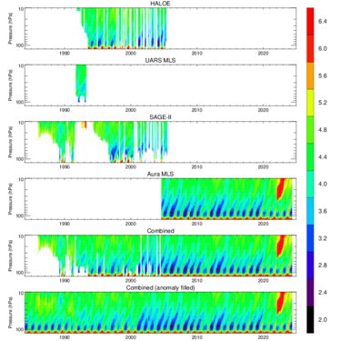
The Stratospheric Water and OzOne Satellite Homogenized (SWOOSH) data set is a merged record of stratospheric ozone and water vapor measurements taken by a number of limb sounding and solar occultation satellites over the previous ~40 years (1984 to present). SWOOSH version 2.6 includes data from SAGE-II/III, UARS HALOE, UARS MLS, and Aura MLS instruments. Version 2.7 includes data from these instruments plus ACE-FTS, OMPS-LP, and SAGE III/ISS. The measurements are homogenized by applying corrections that are calculated from data taken during time periods of instrument overlap.
The primary SWOOSH data product consists of monthly-mean zonal-mean values on a pressure grid. In addition to the primary (zonal-mean) grid, SWOOSH data are also available on 3D (longitude/latitude/pressure), equivalent latitude, and isentropic grids.
The gridded data include the mean, standard deviation, number of observations, and mean uncertainty from each instrument. Also included is a merged (multi-instrument) product based on a weighted mean of the available measurements. Because the merged product contains missing data, a merged and filled product is also provided for (e.g., modeling) studies requiring a continuous dataset.
Point of Contact: Sean Davis, NOAA
Publications
Data Access
Documentation
If you use this data set for a publication, please cite: Davis, S. M., Rosenlof, K. H., Hassler, B., Hurst, D. F., Read, W. G., Vömel, H., Selkirk, H., Fujiwara, M., and Damadeo, R.: The Stratospheric Water and Ozone Satellite Homogenized (SWOOSH) database: A long-term database for climate studies, Earth System Science Data, doi:10.5194/essd-8-461-2016, 2016.