A .gov website belongs to an official government organization in the United States.
Secure .gov websites use HTTPS
A lock () or https:// means you've safely connected to the .gov website. Share sensitive information only on official, secure websites.
Clouds, Aerosol, & Climate: Projects
CP-MIP: Cold Pool Model Intercomparison Project
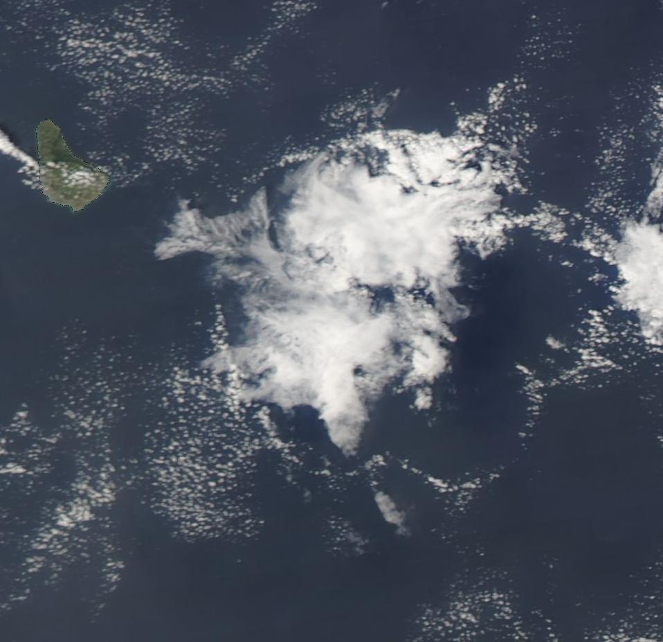
Trade cumulus cold pools underneath a "Flower" type cloud, Barbados. Image: NASA Worldview
CP-MIP studies the fidelity of model representation of convective cold pools. The goals of CP-MIP are the identification, characterization, and quantification of model biases through comparison with observed cold pool statistics, the improved representation of cold pools in simulations, and convergence of models towards a robust basis for the study of cold pools in the atmosphere. CP-MIP develops concepts, analytical approaches, and software tools, and coordinates community efforts to conduct and analyze simulations and observations. The first stage of CP-MIP focuses on shallow convective cold pools over the tropical oceans, which are primarily associated with trade cumulus clouds.
Point of Contact: Jan Kazil, University of Colorado CIRES at NOAA and Raphaela Vogel, University of Hamburg
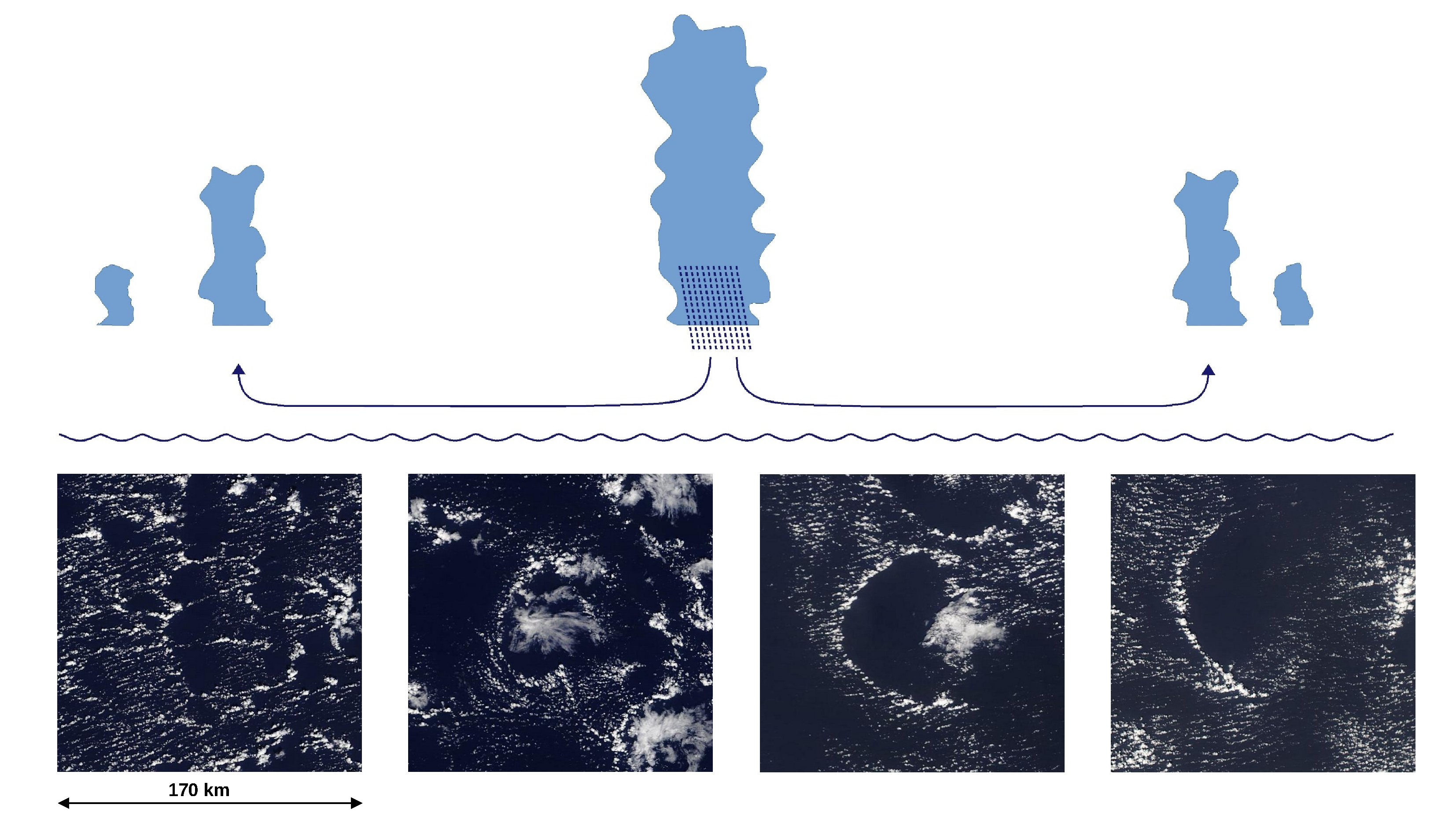
Cold pools are created by cool downdrafts associated with precipitation. Once a downdraft reaches the surface, the cool air spreads outwards, creating a cloud-free region delineated by an arc of convection in the convergence zone. Illustration: Jan Kazil, NOAA / CIRES; Images: NASA Worldview
Characterization and quantification of cold pool properties as simulated by different models:
within individual simulation frameworks, such as large eddy simulations (LES),
across simulation frameworks, such as LES, regional models, and storm-resolving models.
Characterization of simulated cold pools properties and their variability in the context of
the state of the atmosphere, ocean, aerosol, and clouds,
model framework, model assumptions, process representations, simulation setup
Evaluation of simulated cold pool properties with observations,
Identification of causes of biases in simulated cold pools and quantification of their sensitivity to simulation setup and process representations.
Phase 1: Collaboration with EUREC4A-MIP and Lagrangian LES intercomparison
Formulate model outputs and diagnostics within ongoing modeling efforts for CP-MIP.
Develop and distribute software to implement the diagnostics.
Formulate a cold pool analysis protocol, develop and distribute software tools for its implementation.
Collect model output from the participating projects and conduct analysis following the cold pool analysis protocol.
Synthesize the analysis into technical and scientific insights, to be published.
Model output and diagnostics requested for CP-MIP
Time series
Cloud water path
Rain water path
Surface precipitation
Surface latent heat flux
Surface sensible heat flux
Inversion height
Top-of-atmosphere incoming solar flux
Time-height curtains
Pressure
Temperature
Water vapor mixing ratio (specific humidity)
Cloud water mixing ratio
Rain water mixing ratio
Horizontal wind speed U and V
Vertical wind speed variance W2
Vertical wind speed skewness W3
TKE
TKE production due to buoyancy, resolved
3D fields
Every 30 minutes:
Pressure
Temperature
Wind speed U, V, W
Water vapor mixing ratio (specific humidity)
Aerosol number concentration
Cloud microphysical quantities (cloud water, cloud drop number, rain water, rain drop number mixing ratios)
2D fields
High temporal resolution (5 minutes or faster) 2D fields are requested to track the change in cold pool properties and their statistics in the different models. Fields at 10 m are requested as ship and buoy data are adjusted from the instrument altitude to a height of 10 m above the surface using the COARE algorithm (e.g. Quinn et al., 2021).
For models that can flexibly write high-frequency single grid-point output, CP-MIP requests vertical profiles and time series at the following locations for comparison with observations
Barbados Cloud Observatory (BCO) (13.16° N, 59.43° W)
EUREC4A (HALO) circle:
Center (13.3° N, 57.7° W)
North (14.3° N, 57.7° W)
South (12.3° N, 57.7° W)
East (13.3° N, 56.7° W)
West (13.3° N, 58.7° W)
Northwest Tropical Atlantic Station (NTAS) buoy (15° N, 51° W)
The following quantities are requested:
Time series of
10 m temperature
10 m specific humidity
10 m U and V wind
Surface sensible and latent heat flux
Vertical profiles of
T, qv, ql, U, V, W
Preliminary cold pool analysis protocol
Cold pool area fraction and number
Probability density distributions in cold pools of
Temperature
Specific humidity
Wind speed
Mixed layer height
Cold pool size distribution
Correlation with cloud and rain water path
Software
Mixed layer height for cold pool detection
CP-MIP provides code to calculate the mixed layer height using the algorithm developed by Touzé-Peiffer et al. (2022). CP-MIP requests that participants diagnose the mixed layer height in their simulations using this algorithm. This will allow comparison of the mixed layer height across models, as well as its comparison with radiosonde cold pool detections, for which the algorithm was developed.
The algorithm defines the mixed layer height Hmix as the lowest altitude Z above Zmin = 20 m where the virtual potential temperature Θν is higher than its mass-weighted average from Zmin to Z by a fixed threshold ε = 0.2 K. The original algorithm of Touzé-Peiffer et al. (2022) uses Zmin = 100 m.
Θυ is calculated assuming that the air of the lowest layers is not saturated, so that the mixing ratio of liquid water in the air can be neglected. It is hence approximated as Θυ = Θ(1 + 0.61r), r being the mixing ratio of water vapor. The calculation of Hmix thus requires only the vertical profiles of pressure, temperature and humidity.
The code provided contains a calculation of the mixed layer height
as the discrete variable, with model (mass) levels as values
as a continuous variable, using linear interpolation
Download
Fortran code, algorithm only (3.9 KiB) (v1.31, starting height for cold pool detection = 20 m, calculates mixed layer height and the mean ("dry") Θυ in the mixed layer)
Water vapor mesoscale anomaly initialization
Download
Fortran and Python code (15 KiB) (standalone test code and plotting code for the routine "initialize_water_vapor_mesoscale_anomaly")
Kazil, J., R. Vogel, U. Hamburg, P. Alinaghi, N. Antary, L. Bariteau, C. Bayley, P. Blossey, S. Boeing, K. K. Chandrakar, T. Dauhut, L. Denby, A. Ekman, N. Falk, A. Fridlind, S. Ghazaye, T. Heus, F. Hoffmann, M. Janssens, F. Jansson, L. Kang, J.-S. Lim, D. Mechem, R. Neggers, G. Raghunathan, N. Robbins, J. Savre, H. Schulz, S.-I. Shima, P. Siebesma, M. Tang, N. Tobias, G. Torri, S. van den Heever, T. Yamaguchi, T. Yanase, and P. Zuidema, Cold Pool Analysis from the Cold Pool Model Intercomparison Project (CP-MIP) , Americal Meteorological Society (AMS) Annual Meeting, 2025.
Kazil, J., R. Vogel, P. Blossey, S. Boeing, L Denby, S. Ghazayel, T. Heus, R. Neggers, G. Raghunathan, and P. Siebesma, The Cold Pool Model Intercomparison Project (CP-MIP) , Americal Geophysical Union (AGU) Fall Meeting, 2023.