A group of scientists from NOAA ESRL Chemical Sciences Division (CSD) and Global Monitoring Division (GMD) heads to Nevada this month to study why ozone levels there sometimes soar above healthy levels. The Fires, Asian, and Stratospheric Transport - Las Vegas Ozone Study (FAST-LVOS) seeks to understand the major sources of surface ozone in Clark County, Nevada. During the late spring in this area, ozone levels regularly exceed the National Ambient Air Quality Standard (NAAQS) of 70 ppb. Ground-level ozone is a pollutant that can damage people's lungs and can also harm vegetation, including crops.
FAST-LVOS builds on the Las Vegas Ozone Study (LVOS) study conducted by CSD researchers in 2013. During the week of 19-26 May in 2013, ozone concentrations in the Mojave Desert twice exceeded the 75 ppbv NAAQS that was then in place. Scientists found that during this period, high levels of naturally occurring ozone were transported downward from the lower stratosphere to the lower troposphere above the Southwestern U.S. This descending stratospheric air also brought with it additional man-made ozone that had been transported across the Pacific Ocean from Asia. These stratospheric intrusion events can create localized spikes in surface ozone and increased background concentrations over large areas for several days, such as was seen in Las Vegas in May 2013. Without these contributions, the standard would not have been exceeded.
LVOS results show that the unique topography of the Mojave Desert, with intense surface heating and dry air in the late spring and early summer, leads to the formation of very deep convective boundary layers. These layers bring air from the lower troposphere into contact with the ground, including ozone that had been transported there from the lower stratosphere or from Asia.
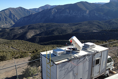
FAST-LVOS researchers will seek to better understand the causes of high-ozone events in Clark County, with emphasis on characterizing the roles of emissions from regional wildfires and pollution from southern California in addition to transport from the stratosphere and from Asia. Ozone measurements will be made from May 18 to the end of June, using the TOPAZ (Tunable Optical Profiler for Aerosols and oZone) lidar. In the original LVOS mission, TOPAZ sat on Angel Peak, just outside the city of Las Vegas, in order to measure up to 3 km above the mountain top, about 6 km above sea level. However, scientists have made improvements that allow the TOPAZ to measure much higher into the atmosphere. For the FAST-LVOS mission, the TOPAZ lidar will be located down in the Las Vegas Valley, providing more accurate measurements of ozone in the city. CSD scientists will also be equipped with more measurement tools to achieve the study goals, including a new MicroDop (micro-pulse Doppler) lidar system, an instrumented van (mobile laboratory), plus ozonesondes from ESRL GMD and an instrumented aircraft from Scientific Aviation. Modeling support for the study will be provided by colleagues at the NOAA Geophysical Fluid Dynamics Laboratory (GFDL) in Princeton, NJ.