2nd Wind Forecast Improvement Project (WFIP2)

wind turbines and instrument deployment locations
The Columbia River Basin of Oregon-Washington is a major supplier of energy to the West Coast, including California.

Where: Columbia River Basin in eastern Oregon-Washington

When: September 2015 - 2017

Wind Energy Research using Lidars / WFIP2 Fact Sheet

The Columbia River Gorge hosts approximately 5 gigawatts of installed wind power capacity (about 7% of the US wind capacity), and is subject to many weather processes that complicate forecasting including mountain wakes, marine pushes, cold pools, and gravity waves. Accurate forecasts of wind have been a challenge in this region.

The second Wind Forecast improvement Project (WFIP2) is a Department of Energy (DOE) and NOAA sponsored field campaign to improve atmospheric understanding, weather prediction modeling, and rotor-layer wind forecasting as they affect wind-energy efficiency and operations. The primary scientific objectives are to characterize complex terrain atmospheric phenomena that impact model accuracy, and to validate and improve weather prediction models. The expected payoffs include improved atmospheric understanding related to wind-energy generation in complex terrain and improvements to numerical weather prediction models that will benefit all weather forecasting.

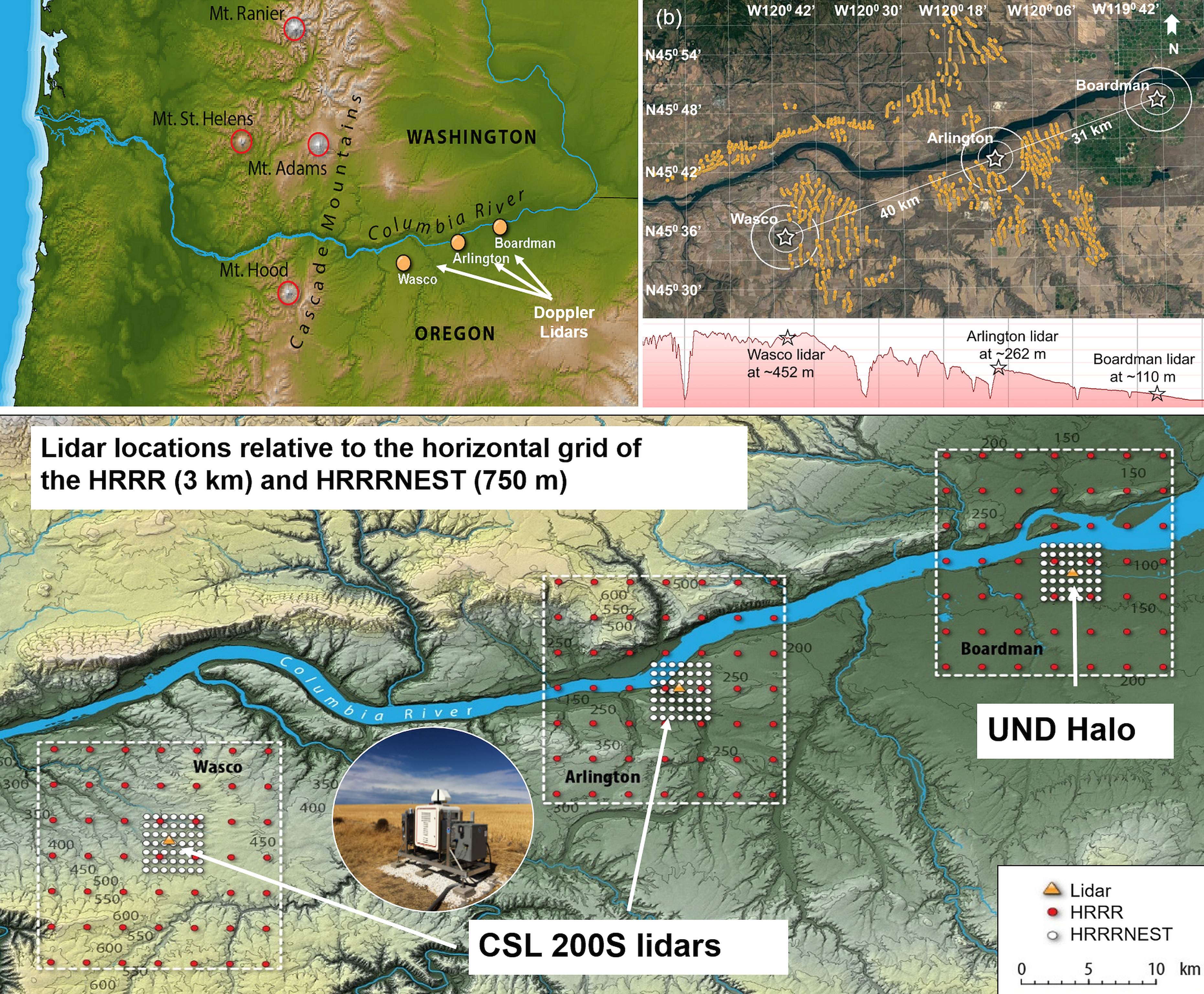
A variety of instruments deploy for an 18 month period 2015-2017 to observe complex mountain wind flow phenomena. CSD provides real-time measurements from two scanning Doppler wind lidar instruments (Dalek 1 and Dalek 2) deployed to the Columbia River Basin for the duration of the experiment. A third lidar (HALO Photonics) will be used for shorter-term case studies. These lidar instruments are operated remotely and supply unique, high-quality, real-time web wind profile data every 15 minutes. This is the first time multiple scanning Doppler lidars run 24/7 in an operational forecasting project, and the first time model-predicted winds are verified at the rotor level using this real-time data.

WFIP2 is a partnership between DOE and DOE National Laboratories (National Renewable Energy Laboratory, Lawrence Livermore National Laboratory, Pacific Northwest National Laboratory, Argonne National Laboratory), NOAA and NOAA Research divisions (Air Resources Laboratory, ESRL CSD, Global Monitoring Division, Global Systems Division, and Physical Sciences Division), University of Colorado Boulder, University of Notre Dame, National Centers for Environmental Prediction, Vaisala, LEOSPHERE, Lockheed Martin, National Center for Atmospheric Research, and local wind energy companies.