AEROMMA Planning

Schedules & Flight Planning

NASA DC-8

May – August 2023 Calendar

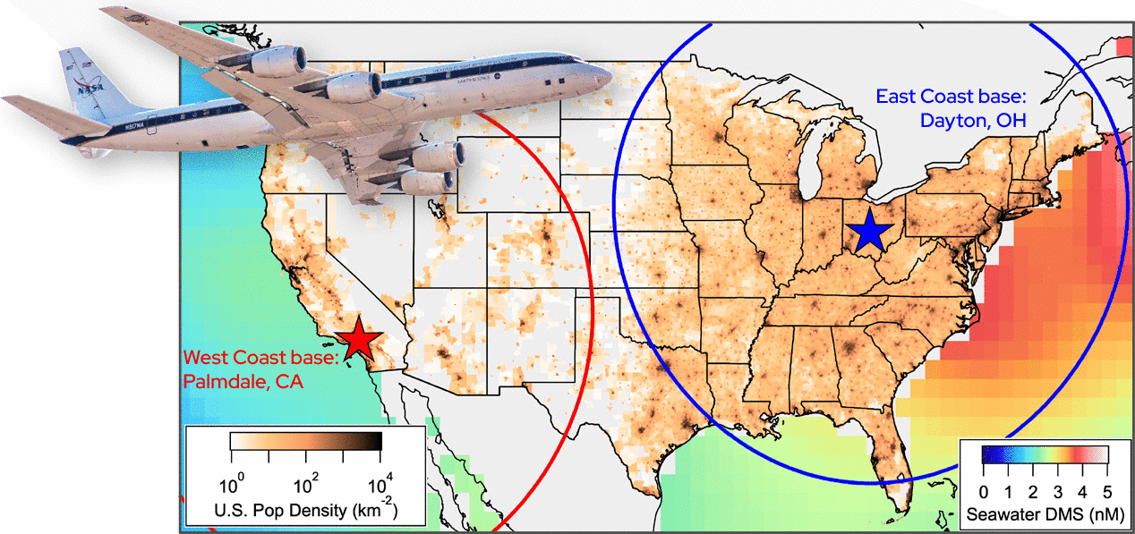
AEROMMA has 150 flight hours for approximately 24 science flights, including test and transit flights, and consists of both a West and East coast deployment. West coast operations will be focused on the Los Angeles basin and the coastal Pacific marine environment. East coast operations will characterize emissions from a number of U.S. megacities.

We anticipate conducting up to 16 flights for urban areas covering weekday/weekend, urban/rural gradients, and diurnal cycles and half a flight each for the Central Valley and the agricultural areas in the upper Midwest. Depending on meteorological conditions each flight to a megacity can cover other smaller cities or more than one megacity. Two flights in Los Angeles and the Central Valley were already conducted during FIREX-AQ in 2019.

For every flight in urban areas, vertical profiles of in-situ measurements of NO2, HCHO, glyoxal, aerosol extinction and other atmospheric components for satellite science will be flown. Emissions and chemical transformation will be determined at plume height, most often in the boundary layer.

We estimate 10 flights dedicated to the survey of the marine atmosphere. West coast operations offer access to various high value targets: marine/urban interface, pristine low NOx marine environments, high DMS emission fields, and the tropical Eastern Pacific. We will largely focus on 3 regions of interest throughout the project: 1) southern, low altitude surveys of the tropics/subtropics with a focus on air/sea exchange, 2) observations in the North Pacific surveying sulfur chemistry and NPF, and 3) coastal Pacific (southern California) where we expect a confluence of NOx gradients from urban influence and high DMS emission fields.

U.S. map overlay
AEROMMA is using the extensively instrumented NASA DC-8 research aircraft for a series of flights in May - August 2023. The aircraft will base in California and Ohio to access several major coastal and inland cities and two ocean basins. The NASA DC-8 flight range is indicated as rings on the above map. Oceans are colored by dimethyl sulfide (DMS), the primary sulfur compound emitted from oceans.

Priorities of the Cities for AEROMMA

Target Urban Flight Planning (updated 17 July 2023)

Forecasting Tools

NOAA Twin Otter

June – August 2023 Calendar

CUPiDS has 150 flight hours for approximately 36 science flights over a time period of six weeks. Flights are anticipated every other day to target coastal dynamics and urban plumes along the Northeast Corridor, and to provide necessary statistics to improve NOAA weather-chemistry model predictions of coastal meteorology and urban plumes of gas-phase species. The NOAA Twin Otter will be based in the NYC area during the field campaign but may travel to other urban centers on the east coast.

The NOAA Twin Otter will perform cross plume transects advancing down wind of major urban centers to track the evolution of the urban plume. Transects oriented perpendicular to advancing onshore flow convergence fronts will be performed to determine the depth and lateral extent of the features and to determine their propagation speed and arrival time. To study the urban heat island effect, the NOAA Twin Otter will perform repeated transects across the urban center to investigate the development of the heat island throughout the day both dynamically and in enhanced aerosol loading.

Long Island NY area
The study region for the NOAA Twin Otter aircraft.