Aerosol Properties & Processes: Projects

Field Campaigns

AEROMMA, Coastal U.S. megacities. Atmospheric Emissions and Reactions Observed from Megacities to Marine Areas (AEROMMA) addresses emerging research needs in urban air quality, marine chemistry influences on cloud formation, and interactions at the marine-urban interface. Researchers will investigate anthropogenic and marine emissions that alter tropospheric composition and impact air quality and climate from science flight and ground site activities based in Palmdale, California, Dayton, Ohio, and the NYC metro area during Summer 2023. More Info

NYC skyline

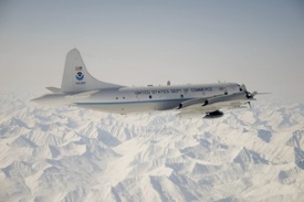
SABRE, Ellington Field. Stratospheric aerosols are an important component of Earth's albedo, and therefore energy balance, and provide surface area for heterogeneous chemistry, which can lead to stratospheric ozone loss. Acquiring a comprehensive database of stratospheric aerosol, trace gas and dynamical observations to establish the baseline state and background variability of the stratosphere is essential. CSL integrates instruments aboard the the NASA WB-57 research aircraft. Test flights commence from Ellington Field, Houston, Texas in January 2022. An Arctic deployment occurs February-March 2023, followed by tropical science Summer 2024 and southern hemisphere science Summer 2025. More Info

SABRE logo

ACCLIP, South Korea. The Asian Summer Monsoon Chemical & CLimate Impact Project (ACCLIP) will deploy from Osan Air Base in South Korea the Summer of 2022. The Asian Summer Monsoon (ASM) is the largest meteorological pattern in the Northern Hemisphere (NH) summer season. Persistent convection and the large anticyclonic flow pattern in the upper troposphere and lower stratosphere (UT/LS) associated with ASM leads to a significant enhancement in the UT/LS of trace species from pollution and biomass burning origins. The monsoon convection occurs over South, Southeast, and East Asia, a region of uniquely complex and rapidly changing emissions tied to both its high population density and significant economic growth. The coupling of the most polluted boundary layer on Earth to the largest dynamical system in the summer season through the deep monsoon convection has the potential to create significant chemical and climate impacts. An accurate representation of the ASM transport, chemical and microphysical processes in chemistry-climate models is much needed for characterizing ASM chemistry-climate interactions and for predicting its future impact in a changing climate. CSL integrates instruments aboard the the NASA WB-57 research aircraft. Test flights commence from Ellington Field, Houston, Texas in Summer 2021. More Info

ACCLIP logo

FIREX-AQ, Western U.S. Fire Influence on Regional to Global Environments and Air Quality (FIREX-AQ) is a NOAA / NASA interagency intensive study of North American fires during the 2019 wildfire season. The project combines the previously separate NASA FIREChem and NOAA FIREX aircraft campaigns to better study the atmospheric effects of wildland and agricultural fires in the U.S. This offers significant advantages to the research community by optimally leveraging the scientific interests, personnel, and assets of NASA, NOAA, other agencies, and academic partners in a fully integrated program of field measurements, modeling, and interpretation. More Info

FIREX-AQ logo

ATom, NASA Armstrong Flight Research Center. The Atmospheric Tomography Mission (ATom) studies the impact of human-produced air pollution on greenhouse gases and on chemically reactive gases in the atmosphere. Airborne instruments look at how atmospheric chemistry is transformed by various air pollutants and at the impact on methane and ozone which affect climate. Observations occur seasonally over three years (2016-2018). Flights aboard NASA's DC-8 originate from the NASA Armstrong Flight Research Center in Palmdale, California, fly north to the western Arctic, south to the South Pacific, east to the Atlantic, north to Greenland, and return to California across central North America for a systematic, global-scale sampling of the atmosphere. More Info

ATom logo

FIREX FireLab, Missoula, Montana. Wildfires have implications for air quality and carbon release, and changes in climate sharpen the problems involving widfires in the western U.S. The Fire Influence on Regional and Global Environments Experiment (FIREX) is a coordinated research effort to understand and predict the impact of North American fires on the atmosphere and ultimately support better land management. Laboratory studies at the USDA Fire Sciences Lab in Missoula commence in the fall of 2016. More Info

stack burn
Fire Science Lab stack burn

SONGNEX, Western U.S. The goal of the Shale Oil and Natural Gas Nexus (SONGNEX) 2015 program is to quantify the emissions of trace gases and fine particles from several different tight oil and shale gas basins in the western U.S., and to study the chemical transformation of these emissions. The study focuses on basins which represent a mixture of oil and gas production regions at various stages of development. This airborne study involves the NOAA WP-3D aircraft mobile platform. More Info

oil and gas drilling site
Oil extraction equipment in Uintah Basin, Utah

SAOP UAS, Svalbard, Norway. Ny-Ålesund is a center for international Arctic scientific research and environmental monitoring. A study of aerosol optical properties (SAOP) with a Manta Unmanned Aircraft System (UAS) operated from the Kings Bay AS research facility in April 2015. CSD deployed two instruments on the Manta UAS, the recently developed miniaturized Printed Optical Particle Spectrometer (POPS) and the miniature Scanning Aerosol Sun Photometer (miniSASP; an upward-looking radiometer (ULR)). The payload measured the vertical profile from 50m up to 3000m over different sea and glacier terrains near Ny-Ålesund. More Info

Manta UAS launch at Kings Bay AS
NOAA Manta Unmanned Aircraft System (UAS) launch

NOAA SEED project. The NOAA Special Early-Stage Experimental or Developmental (SEED) project conducted the very first test flights for new instruments designed to measure properties and climate effects of airborne fine particles (aerosols) using the Manta Unmanned Aircraft System (UAS). CSD developed two new instruments for the Manta, the Printed Optical Particle Spectrometer (POPS) and an upward-looking radiometer (ULR), filling key measurement gaps in the payload. They contribute to a potentially powerful new tool for NOAA to address climate and air quality issues related to aerosols in remote and hard-to-access regions. More Info

NOAA Manta UAS launch
NOAA Manta Unmanned Aircraft System (UAS) launch

SEAC4RS, Houston, Texas. Studies of Emissions and Atmospheric Composition, Clouds and Climate Coupling by Regional Surveys (SEAC4RS) is based out of Ellington Field in August - September 2013. Focused on pollution emissions and the evolution of gases and aerosols in deep convective outflow, and the influences and feedbacks of aerosol particles from anthropogenic pollution and biomass burning on meteorology and climate, the project requires two aircraft to accomplish the goals. The NASA DC-8 provides observations from near the surface to 12 km, and the NASA ER-2 provides high altitude observations reaching into the lower stratosphere as well as important remote sensing observations connecting satellites with observations from lower flying aircraft and surface sites. More Info

SEAC4RS logo

SENEX, Southeast U.S. The goal of the Southeast Nexus (SENEX) 2013 program is to study the interactions between natural and anthropogenic emissions in the southeast at the nexus of the air quality and climate change. Scientists quantify the emissions of greenhouse gases and aerosol, and investigate the roles played by anthropogenic and natural emissions in the formation of ozone and aerosol in the atmosphere. This airborne study involves the NOAA WP-3D aircraft, forecast modeling and surface monitoring networks. More Info

Southeast mountains
Great Smoky Mountains National Park

DC3, Salina, Kansas. The Deep Convective Clouds & Chemistry (DC3) experiment investigates the impact of deep, midlatitude continental convective clouds, including their dynamical, physical, and lightning processes, on upper tropospheric composition and chemistry. Airborne measurements taken from the NASA DC-8 in July 2012 provide in situ observations to characterize the convective storm inflow and provide remote sensing to aid in flight planning and column characterization. More Info

clouds

Saharan Dust, Barbados. Measurements of the optical properties of Saharan dust occur in June 2011. A ground site on the eastern most point of Barbados is an optimal location for sampling the trade winds across the Atlantic from Africa. More Info

Ragged Point, Barbados
Ground site at Ragged Point, Barbados

MACPEX, Houston, Texas. The Mid-latitude Airborne Cirrus Properties Experiment (MACPEX) is an airborne field campaign to investigate cirrus cloud properties and the processes that affect their impact on radiation. The campaign involves the NASA WB-57 based at Ellington Field, TX in the March / April 2011 timeframe. Science flights focus on central North America vicinity with an emphasis over the DoE ARM SGP site in Oklahoma. More Info

MACPEX logo

NACHTT, Erie, Colorado. The primary goal of Nitrogen, Aerosol Composition, and Halogens on a Tall Tower (NACHTT) is to understand why and how a compound usually associated with the atmosphere near oceans – nitryl chloride (NO2Cl) – also forms during the winter nighttime in land-locked regions. NO2Cl breaks apart quickly as the sun rises to release chlorine atoms. Chlorine atoms can react with many other compounds, contributing to smog formation, and can also influence chemical cycles that destroy or produce various greenhouse gases, including ozone and methane. Studies commence February - March 2011 to assess these implications for both climate and air quality. More Info

Erie Tower payload
Boulder Atmospheric Observatory Tower, Erie, CO

CalNex, Southern California. The goal of the California Research at the Nexus of Air Quality and Climate Change (CalNex) 2010 program is to study the important issues at the nexus of the air quality and climate change problems, and to provide scientific information regarding the trade-offs faced by decision makers when addressing these two inter-related issues. The NOAA WP-3D aircraft, the R/V Atlantis ship, and several ground sites were involved in this project. Comprehensive data analysis followed the completion of this project in July 2010. More Info

Haze over LA Basin
Haze over East Los Angeles

ARCPAC, Fairbanks, Alaska. As part of the International Polar Year of 2008, NOAA engaged in an airborne field measurement campaign targeted at improving understanding climate-relevant processes. The Aerosol, Radiation, and Cloud Processes affecting Arctic Climate (ARCPAC) effort was focused on direct measurements of properties and processes that can be used to reduce uncertainty in radiation and climate models. The measurements were made in the Alaskan Arctic to closely coordinate with remote-sensing and in situ observations from aircraft and ground sites in the vicinity of Barrow, Alaska. More Info

WP-3D over Brooks Range
NOAA WP-3D aircraft over the Brooks Range, AK

Prior field campaigns in which CAP instruments were a part of the payload: