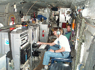
Remote Sensing Aircraft Instrumentation
The primary instrument to be deployed on the ETL-chartered aircraft will be the down-looking NOAA ozone/aerosol DIAL system, which produces profiles of ozone and aerosol structure in the boundary layer and lower troposphere. The lidar system employs four wavelengths (277 nm, 292 nm, 313 nm, 319 nm) in the ultraviolet spectral region for ozone measurements. Each wavelength is characterized by a different ozone absorption cross-section, enabling measurements to be made over a wide range of ozone values. The multi-wavelength capability of the system also provides flexibility for correction of potential errors in ozone calculations caused by aerosol backscatter gradients. Ozone measurements are typically made at a horizontal resolution of approximately 600 m and vertical resolution of 90 m. Precision of the ozone measurement ranges from about 3 to 10 ppbV, depending on range and amount of intervening ozone. A fifth system wavelength at 360 nm, which is minimally absorbed by ozone, is used to measure aerosol backscatter profiles; resolution for the aerosol measurements is 600 m horizontally and 15 m vertically. Onboard the aircraft, a global positioning system provides a precise location for each lidar measurement. Data are analyzed and displayed on board the aircraft in real time, enabling adjustment or changes in the science mission if unexpected features or events are observed.
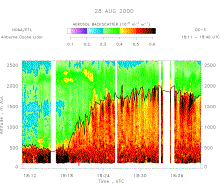
A key measurement objective for the New England study will be characterization of the structure of the boundary layer, including mixing layer height. Mixing layer height is estimated from the gradient of the lidar aerosol signal, as indicated in the figure. Investigation of mixed layer properties over different surfaces and the relationship with ozone concentrations will be important for understanding layering, transport, and vertical mixing. To provide additional information on surface properties, we also plan to mount a downward looking infrared radiometer to measure surface skin temperature on the aircraft alongside the ozone lidar.
At this time, we are investigating the feasibility and cost of incorporating a dropsonde capability on the ETL remote sensing aircraft. Dropsondes, particularly over the ocean, will provide information on wind structure associated with pollution layers, providing important information on the potential source of plumes observed distant from known sources. Because the aircraft will be flown unpressurized, installation of a dropsonde-launching configuration is anticipated to be relatively economical.