A .gov website belongs to an official government organization in the United States.
Secure .gov websites use HTTPS
A lock () or https:// means you've safely connected to the .gov website. Share sensitive information only on official, secure websites.
Land-Atmosphere Feedback Experiment (LAFE)
Where: Atmospheric Radiation Measurement (ARM) Southern Great Plains (SGP) Central Facility, Lamont, OK
When: July - September 2017
The Land-Atmosphere Feedback Experiment (LAFE) aimed to investigate feedbacks occurring between different land surface types and the overlying atmosphere to improve turbulence parameterizations in numerical weather prediction models. The large suite of various instrumentation was deployed to the ARM SGP Central Facility (C1) near Lamont, OK to provide meteorological information in addition to the existing long-term (2013 - current) measurements from ARM SGP atmospheric observatory.
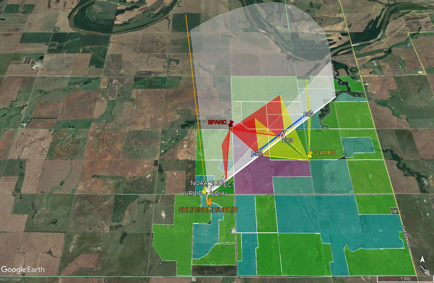
Figure 1. Three scanning lidar systems (UDIAL, URLID, and NOAA DLID) were located 300 m north of the SRL and scanning in elevation above the main RHI (thick white planes) and along the line between of four energy balance stations, EC1-EC4 (thick white line). Dual-Doppler lidar scans were also performed at the tower locations using a combination of the NOAA DLID and the DLIDs included with the SPARC (red planes) and CLAMPS (yellow planes). The field types are indicated by color: cyan denotes pasture, green denotes farm fields (which were mainly wheat stubble or soybeans), and purple is conservation research program land that has native grasses that are about 0.6 m tall.
In-situ measurements of temperature, humidity, wind speed and direction, pressure, rainfall, soil temperature and soil moisture, fluxes of momentum, sensible heat, latent heat, and CO2 at 2 m and 10 m above ground level (AGL) were available from 3 micrometeorological towers installed by the NOAA Atmospheric Turbulence and Diffusion Division (ATDD) and the tower installed by the University of Hohenheim (UHOH). The suite of deployed remote-sensing instruments consists of several lidars (such as NOAA 200S and UHOH HALO, UHOH Raman, and Clams DLIDs) to provide profiles of temperature, water, vapor, and wind field components. Detailed overview of key instruments that participated in LAFE, measured quantities, as well as scientific objectives of the LAFE, are summarized in Wulfmeyer, V., D.D. Turner, B. Baker, R. Banta, A. Behrendt, T. Bonin, W.A. Brewer, M. Buban, A. Choukulkar, E. Dumas, R.M. Hardesty, T. Heus, J. Ingwersen, D. Lange, T.R. Lee, S. Metzendorf, S.K. Muppa, T. Meyers, R. Newsom, M. Osman, S. Raasch, J. Santanello, C. Senff, F. Späth, T. Wagner, and T. Weckwerth, A new research approach for observing and characterizing land-atmosphere feedback, Bulletin of the American Meteorological Society, doi:10.1175/BAMS-D-17-0009.1, 2018.
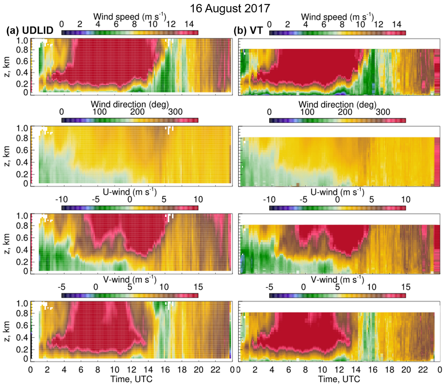
Figure 2. Diurnal variability of wind fields from (a) UHOH HALO Doppler lidar (UDLID) measurements and (b) multi-lidar "virtual tower" (VT) low-elevation scans is shown for a sample day of strong winds on 16 August 2017. The UDLID operated at the scanning sequence known in the literature as "6-beam scans" when a high-frequency laser beam (~ 1 sec per each beam) is pointing at six-direction with the azimuth angles of 0, 60, 120, 180, 240, and 300 degrees and the maintaining the 45-degree elevation angle. All profiles were obtained from 75 m AGL with a vertical resolution of 23 m and a temporal resolution of ~ 1 min. The VT profiles were obtained from 3m AGL with a vertical resolution of 3.3 m and a temporal resolution of 7.5 min The maximum range of VT profiles is 0.8 km AGL due to the employed scanning pattern.
During LAFE, three scanning lidar systems (NOAA CSL 200S, CLAMS, and SPARC) provided synchronized measurements in the RHI mode slicing the atmosphere at low-elevation angles. The combination of measurements from these systems allowed us to obtain a 3D wind field along "virtual" towers and construct wind profiles from the surface to 800 m AGL with high (~3 m) vertical resolution at the lidar beams crossing points (Figure 1).
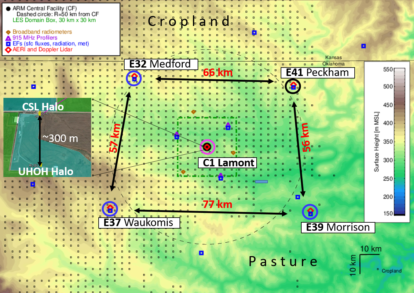
Figure 3. Location of Halo Streamline HR Doppler Lidars at the ARM Climate Research SGP Facility (black circles) superimposed on area topography from a 750-m resolution HRRR simulation. Distances between The ARM central facility (C1) near Lamont and at the four extended facilities near Medford (E32), Waukomis (E37), Morrison (E39), and Peckham (E41) indicated by black arrows. Small black squares are grid points of the 3-km operational HRRR model.
An example of wind fields obtained from the HALO UDLID and the multi-Doppler "virtual tower" technique is illustrated in Figure 2.
The unique LAFE dataset is used for a detailed study of wind flow and dynamic processes occurring around the evolution of the nocturnal low-level jet (LLJ) phenomena. The extensive analysis of data from the LAFE has been expanded to other summer months, years, and SGP sites equipped with HALO Streamline Doppler lidars (Figure 3). The long-term lidar measurements were used to quantify spatial variability of winds and LLJ properties between sites of different land use and for the evaluation of the NWP High Resolution Rapid Refresh version 3 (HRRRv3) operational model.