Atmospheric Remote Sensing: Projects

Field Campaigns

AMED, NW Colorado. The Airborne Measurements and analysis of Emissions over the Denver-Julesburg & Piceance (AMED) is focused on quantifying emissions of methane, ethane and selected volatile organic compounds (VOCs) from the Denver-Julesburg and Piceance basins in Colorado. CSL deploys a PickUp-based Mobile Atmospheric Sounder (PUMAS) Micro-pulse Doppler lidar (MicroDop) to measure wind and turbulence profiles, and boundary layer height to constrain uncertainty in emission estimates due to variability in wind field. More Info

PUMAS

AWAKEN, Central Oklahoma. The American WAKE experimeNt (AWAKEN) is a comprehensive wind energy study that aims to investigate the flow physics of large multi-turbine arrays. It will use observational data from remote sensing and in-situ instruments to improve wake model prediction accuracy and decrease the cost of wind energy. CSL deploys a PickUp-based Mobile Atmospheric Sounder (PUMAS) Micro-pulse Doppler lidar (MicroDop) to measure wake behavior downwind of the King Plains wind farm from 15 August to 15 September 2023. The PUMAS motion-stabilized lidar measurements through the boundary layer will be used to examine wind flow and turbulence modified by wind farms and provide insight into wind plant wake dynamics along PUMAS tracks at various distances from the wind farm. More Info

Oklahoma wind farm

CUPiDS, NYC region. The Coastal Urban Plume Dynamics Study (CUPiDS) supports the overall Atmospheric Emissions and Reactions Observed from Megacities to Marine Areas (AEROMMA) science objectives related to urban emissions as affected by coastal meteorology. Researchers deploy an airborne scanning Doppler lidar aboard a NOAA Twin Otter based in the New York City region during Summer 2023. In addition, ground-based observations from two lidars stationed at the Yale Coastal Field Station (YCFS) in south central Connecticut will help address several key science questions. More Info

NYC skyline

CalFiDE, California. The California Fire Dynamics Experiment (CalFiDE) is a six week study of wildfire behavior and its response to spatially and temporally evolving wind fields in the California summer of 2022. The experiment will provide new data on the emissions and chemistry leading to ozone formation in wildfire plumes and in populated areas impacted by these plumes. Instrumented mobile platforms include a NOAA Twin Otter, outfitted with a scanning Doppler lidar to measure horizontal wind fields, plume vertical dynamics, spatial extent and transport. Airborne CSL instruments include NightFox (for FRP) and a Micro-pulse Doppler lidar (MicroDop) sidescanner for lidar. For ground-based measurements, CSL deploys a Stationary scanning Doppler lidar On a Trailer (StaDOT) and a PickUp based Mobile Atmospheric Sounder (PUMAS) micro-pulse Doppler lidar. More Info

CALFiDE logo

SITE, Lakeland, FL. The System Integration and Test Experiment (SITE) is based out of the NOAA Aircraft Operations Center in Lakeland, Florida. Over 8 weeks ARS scientists install and test an airborne Micro-pulse Doppler lidar (MicroDop) system on the NOAA WP-3D and NOAA Twin Otter research aircraft to evaluate the instrument's sensitivity and performance for measurements of dynamics associated with organized convective systems, diurnal coastal flows and wildfires. More Info

SITE logo

SUNVEx, Los Angeles, CA and Las Vegas, NV. Southwest Urban NOx and VOC Experiment (SUNVEx) addresses emerging research needs in urban air quality ahead of AEROMMA and CUPiDS. Researchers will investigate anthropogenic emissions that alter tropospheric composition and impact air quality and climate from ground-based activities during Summer 2021. Measurements from CSL's mobile Doppler lidar provide complementary dynamics data to improve model representations of urban meteorology and relationships between extreme heat, emissions and photochemistry. More Info

LA haze

DCFlux, Washington, D.C.. The Washington D.C. Flux Study (DCFlux) is part of the Northeast Corridor Urban Test Bed, a NIST led effort to quantify greenhouse gas (GHG) fluxes in the US Northeast. CSL deploys a scanning Doppler lidar instrument to downtown Washington D.C. in the Spring 2021, to measure mean wind profile in the lower part of the atmosphere, and turbulence information, including the mixing height. These measurements will be used to evaluate and improve the atmospheric transport models that are coupled with observations of GHG concentrations to estimate urban GHG emissions. More Info

Washington D.C.

PUMAS, Colorado Front Range. Coupling Doppler lidar measurements with mobile platforms allows researchers to investigate the spatial and temporal evolution of complex flows on regional scales. For the PickUp based Mobile Atmospheric Sounder (PUMAS) campaign, researchers mounted the Micro-pulse Doppler lidar (MicroDop) in the bed of the CSL Ford pickup truck to investigate several complex flow phenomena along the Colorado Front Range. More Info

instrument in truck bed
MicroDop lidar mounted in pickup truck.

COVID-AQS, Boulder, Colorado. The COVID-19 outbreak was a never before seen health crisis that completely disrupted our way of life. It provides an unprecedented opportunity to assess changes in U.S. emissions and urban air quality due to decreased traffic and economic activities. Measurements made from the NOAA David Skaggs Research Center in Spring 2020 will be analyzed and compared to past in situ measurements at CSL, along with satellite data, and used in regional air quality models. More Info

instrument inlets
Instrument inlets at the NOAA lab.

ATOMIC, tropical North Atlantic east of Barbados. Clouds close to the ocean surface, a type of "shallow convective cloud," are critical to understanding climate and weather, but are poorly represented in models. The Atlantic Tradewind Ocean-Atmosphere Mesoscale Interaction Campaign (ATOMIC) aims to study air-sea interaction processes to advance understanding and prediction of U.S. weather and climate. CSD deploys a Micro-pulse Doppler lidar (MicroDop) on NOAA's R/V Ronald H. Brown for the six week campaign January-February 2020. More Info

shallow convective clouds

FIREX-AQ, Western U.S. Fire Influence on Regional to Global Environments and Air Quality (FIREX-AQ) is a NOAA / NASA interagency intensive study of North American fires during the 2019 wildfire season. The project combines the previously separate NASA FIREChem and NOAA FIREX aircraft campaigns to better study the atmospheric effects of wildland and agricultural fires in the U.S. This offers significant advantages to the research community by optimally leveraging the scientific interests, personnel, and assets of NASA, NOAA, other agencies, and academic partners in a fully integrated program of field measurements, modeling, and interpretation. More Info

FIREX-AQ logo

PISTON, Philippine Sea. During two cruises in Summer and Fall of 2018, researchers will collect air-sea flux, cloud, and boundary-layer turbulence observations aboard the University of Washington R/V Thomas G Thompson for the Propagation of Intra-Seasonal Tropical Oscillations (PISTON) field campaign. Large masses of atmospheric convection propagating from the Indian Ocean into and across the Pacific Ocean is a well-known precursor to extreme weather in the U.S. By improving our understanding of the convective and air-sea interaction processes, we can improve U.S. weather forecasts at 1-3 week timescales. More Info

R/V Thomas G Thompson

CPEX, Boulder, Colorado. The purpose of the Cloud Properties Experiment (CPEX) is to evaluate instrumentation for cloud properties, especially those that may be useful additions to the SURFRAD (Surface Radiation) Network, and to augment a data set for a cloud forecasting study. CSD installed a scanning Doppler lidar (Dalek) on Table Mountain for measurements during the Summer of 2018. More Info

Dalek lidar installation
Scanning Doppler lidar installation on Table Mountain

LAFE, ARM SGP Central Facility in Oklahoma. The Land-Atmosphere Feedback Experiment (LAFE) aimed to investigate feedbacks occurring between different land surface types and the overlying atmosphere to improve turbulence parameterizations in numerical weather prediction models. CSL deployed a commercial doppler lidar to the Atmospheric Radiation Measurement (ARM) Southern Great Plains (SGP) Central Facility (C1) in Oklahoma to provide horizontal wind, turbulence, and aerosol backscatter intensity profiles. More Info

ARM SGP C1
ARM Southern Great Plains (SGP) Central Facility in OK

FAST-LVOS, Angel Peak, Nevada. The Fires, Asian, and Stratospheric Transport - Las Vegas Ozone Study (FAST-LVOS) seeks to understand the major sources of surface ozone in Clark County, Nevada, and study why ozone levels there sometimes soar above healthy levels. The study also puts emphasis on characterizing the roles of emissions from regional wildfires and pollution from southern California in addition to transport from the stratosphere and from Asia. The tunable optical profiler for aerosol and ozone lidar (TOPAZ) and a new Micro-pulse Doppler lidar (MicroDop) system are stationed in the Las Vegas Valley mid May through June 2017, providing more accurate measurements of ozone in the city. More Info

Mobile Lab atop Angel Peak
TOPAZ & MicroDop lidar installation

CABOTS, California. The California Baseline Ozone Transport Study (CABOTS) was designed to quantify California's starting point for complying with the federal ozone standard. CSD's tunable optical profiler for aerosol and ozone lidar (TOPAZ) measures vertical profiles of ozone to characterize how much ozone from across the Pacific is mixing down to the surface in the San Joaquin Valley of central California (Visalia). TOPAZ produces these daily profiles of ozone from the ground to about 3 km aloft, for both the Spring (the "transport" season, late May to mid June) and Summer (the "ozone" season when locally produced ozone is high, July to August) CABOTS 2016 study periods. More Info

TOPAZ instrument truck
TOPAZ lidar scanner installed in truck

WFIP2, Columbia River Basin, Oregon. The second Wind Forecast Improvement Project (WFIP2) is a Department of Energy and NOAA sponsored effort to improve short-term weather forecast models and increase understanding of physical processes such as stability, turbulence, and low-level jet that affect wind energy generation in regions of complex terrain. A variety of instruments deploy to the Pacific Northwest for an 18 month period 2015-2017 to observe mountain wind flow phenomena. Our primary scientific objectives are to characterize complex terrain atmospheric phenomena that impact model accuracy, and to validate and improve weather prediction models. CSD provides real-time measurements from two scanning Doppler lidar (Dalek) to study atmospheric dynamics in complex terrain in the Columbia River Basin for the duration of the experiment. A third scanning Doppler lidar (HALO) is used for shorter-term case studies. More Info

Dalek02 instrument
Scanning Doppler lidar (Dalek02) instrument

XPIA, Erie, Colorado. The Experimental Measurement Campaign (XMC) for Planetary Boundary Layer (PBL) Instrument Assessment (XPIA) is a DOE funded study to validate methods to make high fidelity measurements of the three dimensional wind fields of wind farm inflows and wake flows using remote sensing instrumentation. In addition, this study validates measurements from the Texas Tech University Ka-band radars and the Axys Vindicator lidar. CSD deployed the high-resolution Doppler lidar (HRDL) and two scanning Doppler wind lidar (Dalek) instruments at the Boulder Atmospheric Observatory (BAO) tower in March 2015. More Info

Dalek01 instrument
Scanning Doppler lidar (Dalek01) instrument

FRAPPÉ / DISCOVER-AQ, Colorado Front Range. The NSF sponsored Front Range Air Pollution and Photochemistry Éxperiment (FRAPPÉ) and the NASA sponsored Deriving Information on Surface conditions from Column and Vertically Resolved Observations Relevant to Air Quality (DISCOVER-AQ) mission take place in Summer 2014. Three aircraft, including the NASA P-3 and King Air and the NSF / NCAR C-130 make observations characterizing the local to regional chemical environment including photochemistry, oxidant and aerosol formation and fate, flow and recirculation patterns and large-scale inflow. Instruments at the Boulder Atmospheric Observatory (BAO) tower provide both ground-based measurements and vertical profiles of a suite of compounds that contribute to aerosol and ground level ozone. More Info

inversion over Baseline Reservoir
Inversion along the Colorado Front Range

INFlux, Indianapolis, Indiana. The Indiana Flux Study (INFlux) began in the Spring of 2013 with the installation of a scanning Doppler lidar (HALO) instrument on a rooftop in Indianapolis. HALO collects high-resolution vertically staring data and takes vertical velocity variance and aerosol backscatter signal strength profiles. A second installation with the high-resolution Doppler lidar (HRDL) instrument occurs in the Spring of 2014. More Info

HALO instrument installation
HALO lidar instrument rooftop installation

DISCOVER-AQ, Houston, Texas. Deriving Information on Surface Conditions from Column and Vertically Resolved Observations Relevant to Air Quality (DISCOVER-AQ) bases their third deployment out of Ellington Field in September 2013 and the tunable optical profiler for aerosol and ozone lidar (TOPAZ) makes ground-based measurements. DISCOVER-AQ is a four-year campaign to improve the use of satellites to monitor air quality for public health and environmental benefit. The Summer 2014 deployment is closely coordinated with FRAPPÉ along the Colorado Front Range. More Info

iUniversity of Houston Moody Tower air quality research site
Houston area industry skyline

LVOS, Angel Peak, Nevada. The Las Vegas Ozone Study (LVOS) was designed to assess the influence of long-range transport from Asia and stratosphere-to-troposphere transport (STT) on surface ozone concentrations in Clark County, and to estimate the relative contributions of these processes to high ozone events compared to local ozone production, regional transport from Southern California, and other sources such as wildfires. The tunable optical profiler for aerosol and ozone lidar (TOPAZ) is stationed on a mountain top overlooking Las Vegas during May - June 2013 for near daily measurements. More Info

TOPAZ instrument installation
TOPAZ lidar scanner installed atop Angel Peak, NV

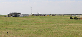
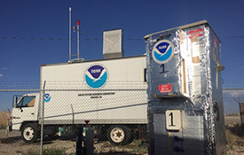
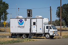
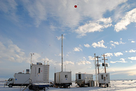
E&E UBWOS, Horse Pool, Utah. The Energy and Environment - Uintah Basin Winter Ozone Study (E&E UBWOS) was designed to study the causes of high wintertime ozone observed in the Uintah Basin. Scientists constructed a ground site of instruments in the winters of 2012, 2013, and 2014 to study sources of VOCs, NOx and particles, ozone formation chemistry in areas of enhanced UV radiation from snow cover, unique radical sources (HONO, CH2O, ClNO2) and the role of transport. The high-resolution Doppler lidar (HRDL) and the tunable optical profiler for aerosol and ozone lidar (TOPAZ) are on the ground for this project. More Info

UBWOS ground site
Trailers at ground site near Horsepool, UT

SONNE, Erie, Colorado. Summer Ozone Near Natural gas Emissions (SONNE) was designed to examine the effects of photochemical processing and characterize the gas-phase composition in the vicinity of oil and natural gas production in Wattenberg Field of the Denver-Julesburg Basin during the summertime in 2012. Scientists constructed a ground site of instruments to study VOC emissions and gas-phase composition of the ambient air. More Info

Erie Tower
Boulder Atmospheric Observatory Tower, Erie, CO

DYNAMO 2011, Indian Ocean. The Dynamics of the Madden-Julian Oscillation (DYNAMO) observation campaign focuses on the Madden-Julian Oscillation and tropical intraseasonal variability in the tropical Indian Ocean region. The project consists mainly of a sounding-radar array formed by research vessels and island sites and enhanced moorings inside and near the array. CSD deployed the high-resolution Doppler lidar (HRDL) aboard the R/V Roger Revelle operated by Scripps Institution of Oceanography. More Info

R/V Roger Revelle

TWICS 2011, south of Boulder, Colorado. The Turbine Wake and Inflow Characterization Study (TWICS) uses a high-resolution, scanning Doppler lidar (HRDL) to take a detailed look at the atmosphere in front of and behind one of the large turbines at NREL's National Wind Technology Center south of Boulder: a 2.3-megawatt graceful giant that stretches 100 meters (328 feet) to the central hub, with three 45-meter (148-foot) blades. The goal of the project is to study the wake effect of wind turbines for improved efficiency and reduced damage. More Info

wind turbine
National Wind Technology Center wind turbine

CalNex 2010, Southern California. The goal of the California Research at the Nexus of Air Quality and Climate Change (CalNex) 2010 program is to study the important issues at the nexus of the air quality and climate change problems, and to provide scientific information regarding the trade-offs faced by decision makers when addressing these two inter-related issues. CSD deployed the tunable optical profiler for aerosol and ozone lidar (TOPAZ) aboard the NOAA Twin Otter. Comprehensive data analysis followed the completion of this project in July 2010. More Info

research team with NOAA Twin Otter
CalNex research team from the NOAA Twin Otter