A .gov website belongs to an official government organization in the United States.
A lock () or https:// means you've safely connected to the .gov website. Share sensitive information only on official, secure websites.
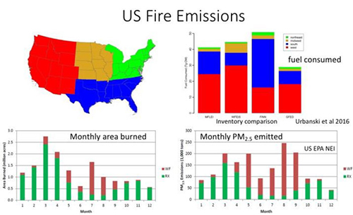
Most fire emissions generated in the United States each year are from wildfires in western states and from agricultural fires in the southeast. Wildfires burn slightly more fuel and therefore have overall larger emissions, but agricultural fires dominate the area burned. FIREX-AQ will investigate both types of fires. Wildfires generally result in exposures with larger pollution concentrations over larger areas, and cause both local and regional air quality impacts. Their emissions are often transported thousands of miles and can impact large regions of the US at a time. To date wildfire fire emissions are still poorly represented in emission inventories.
Agricultural fires are smaller and less intense than most wildfires but occur more frequently throughout the whole year. They are usually ignited during periods that minimize population exposure and air quality impacts, but can cause regional background concentrations of pollutants to increase, are generally in closer proximity to populations, and are responsible for a large fraction of the US aerosol pollution. Data on agricultural fire emissions are even more poorly represented in emission inventories than wildfires.
Fires emissions are complex, consisting of hundreds of different compounds in both the gas phase and in the condensed phase (solid or liquid) as particulate matter. There is a dynamic exchange between these phases as the fire plumes age, with some compounds evaporating to the gas phase and others undergoing gas phase reactions to produce compounds that re-condense to the particle phase. Novel compounds are being discovered as more sophisticated analytical techniques have been applied.
The fundamental chemistry of some of these compounds in the atmosphere is unknown. What is clear is that fire emissions often have broad-scale impacts on ozone formation, especially when mixed with urban emissions, and can be decisive factors in triggering air quality exceedances.
The overarching objective of FIREX-AQ is to improve understanding of wildfire and agricultural fire impacts on air quality, weather, and climate. It will use detailed measurements of gases and aerosols emitted from wildfires and agricultural fires to address science topics including: how emissions depend on fuel type (meaning major tree species or crops), whether fires are flaming or smoldering, how the interaction between fire and weather controls the injection of smoke into the air, how chemical transformations change the composition of smoke and its impacts on local and regional air quality, and how satellite data can be used to estimate emissions more accurately.
For detailed information, download the FIREX-AQ White Paper
Broad science targets for the FIREX-AQ campaign are presented with background information and explanations of needs. Each target is associated with specific science questions.
An emissions factor is a measure of the quantity of a pollutant released to the atmosphere by an event such as a wildfire or agricultural burn. Fuel-specific emissions factors relate the amount of smoke released by different types of fuels, such as pine, sagebrush, grass, duff, etc to the amount of fuel burned. This information is necessary for accurately predicting and assessing the impact of wildfire emissions on the atmosphere.
Determination of emission factors is difficult. Although studies of emission factors have been carried out in open air conditions as well as in laboratories, large uncertainties remain. Many different parameters influence fire emission factors, creating another series of difficult challenges for scientists studying smoke in the real world. For example, weather conditions can influence the way fire burns, and the emissions it produces; past weather influences water content of materials on the ground, and hence their burning. Finally, emission factors can vary widely, even for a given fuel tested in the laboratory, based on the nuances of how the fuel burns on any given test.
Another major challenge in determining emission factors is that data in close proximity to fires is relatively scarce. The most comprehensive study on emissions factors drew from just 39 fires sampled during eight field campaigns. For context, the National Interagency Fire Center tracked more than 58,000 wildfires in 2018. Sampling during the FIREX-AQ mission will add significantly to this data.
Further, traditional airborne field campaigns have not been carried out with detailed knowledge of fuels and terrain that were being burned.
Advances in technology and the chemistry of smoke add new value to the FIREX-AQ measurements. For example, the FIREX FireLab 2016 experiment in Missoula, MT, which applied new analytical techniques to characterize fire emissions, resulted in a significant change in the way that experimenters might try to apply emissions factors to fires. In a highly controlled experimental setting, researchers were able to identify a significant fraction of volatile organic compounds (VOCs) that were previously unidentified in emissions of North American wildfires. They also identified semivolatile organic compounds, (SVOCS), which can exist as a particle or gas and are known to include toxins known to be hazardous to human health. The gas-particle exchange of these semi-volatile organic compounds (SVOCs) is an important aspect of fire plume chemistry that requires further study. The powerful analytical tools now available for FIREX-AQ will advance this scientific understanding.
Over 90 percent of the mass detectable by a state-of-the-art mass spectrometer were identified. Many of the instruments used will be deployed in FIREX-AQ. In previous work, only 50 to 75 percent of of the detected mass was identifiable.
The FIREX FireLab experiment also allowed scientists to develop a better process-level understanding of the dependence of emissions on the fire itself. Researchers found that the temperature of the fire was important to determining the composition of the smoke. They found they could explain around 85 percent of the variability of the VOC emissions once they knew how hot a fire was. Some types of VOCs were emitted primarily from high-temperature burns, while others were emitted from low-temperature burns. A single fire burns at both higher and lower temperatures over its course, releasing different VOCs at various stages. Those compounds released from low-temperature burns have properties that make them more likely to form aerosols in the fire plumes.
Collecting FIREX-AQ data with an eye on these recent laboratory measurements will broaden the characterization of fire emissions and be used to refine and improve emission inventories. These measurements will be critical to addressing science question #1 and associated sub-elements.
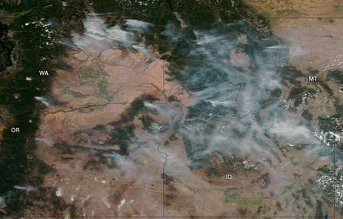
Satellite-borne instruments are important tools for estimating global fire emissions, when data on fuel loading and the fuel-specific emission factors discussed above are available. The satellites can provide burned area estimates derived from a variety of instruments, such as the Advanced Baseline Imager (ABI) on NOAA's GOES-West satellite and MODIS (Moderate Resolution Imaging Spectroradiometer) on NASA's Terra satellite. Terra is a polar-orbiting satellite that collects observations during multiple satellite overpasses, thus increasing the chance to observe locations free of cloud cover. However, while the resolution of the MODIS burned-area product is adequate for estimates of large western wildfires, it is not sufficient for detecting many small agricultural fires in the southeast. Geostationary satellites like NOAA's GOES-West have been able to capture more small fires, even though the instrument resolution was low, simply because they were overhead when small (brief) fires were burning.
Satellite observations in the infrared spectrum are now capable of detecting fires at a spatial resolution of 1 kilometer, but only when fires are actively burning and are unobscured by clouds at the time the satellite is in view of the fire. In an analysis of fire detection products over the U.S., one 2012 study found that 65 percent of active fire detections in croplands were not accompanied by a burned area value from the satellites. This fraction rose to 70 percent in the southeastern U.S.. While the detections are valuable for detecting small cropland fires, they were found to add only 4 percent to total burned area estimated from the MODIS burned area product. Focusing more generally on small fires, a 2012 study estimated that small fires actually increase the global burned area by 26 percent. As with emissions factors, this disparity emphasizes the need to validate information on the contribution of small fires to overall emissions.
It is important to note that many satellite products (e.g., retrievals from ABI, VIIRS, Landsat8/OLI) now offer higher spatial resolution, more frequent coverage, and greater spectral information than was available previously.
To accurately estimate fire emissions from “bottom up” information, the amount of fuel consumed must be known. The total amount of fuel contained in a given area of unique ecosystems can vary by a factor of 100, and the amount of fuel dry enough to burn on a given day further varies with weather conditions. One 2006 study demonstrated that even in the same ecosystem, the fraction of available fuel consumed by a fire can vary by a factor of 10 spatially, dependent on the fuel conditions and fire severity. This tremendous variability emphasizes the need for accumulating statistics by various research methods in field campaigns.
More recently, satellite measurements of radiant energy output from a fire have been used to estimate fuel consumption. Hence, Fire radiative energy, or FRE, has been suggested as a methodology for estimating fire emissions from the top down. As these approaches have matured, their application has been hampered by a lack of quantitative validation data for fire energetics derived from satellite observations.
Satellites can also provide information about concentrations of some chemicals including ozone, carbon monoxide, nitrogen dioxide, formaldehyde and methane. Measurements with unprecedented spatial resolution will be available during FIREX-AQ, presenting an opportunity to compare observations from the TROPOMI (TROPOspheric Monitoring Instrument) onboard the European Space Agency's Sentinel-5 Precursor satellite with measurements taken from aircraft flying in smoke plumes. Observations from other satellites will also be useful for establishing rough estimates of trace gas emissions from fires. These satellites will provide additional value in assessing the contributions of man-made pollution mixing with fire smoke.
Satellite retrievals are relevant to many FIREX-AQ science topics, and are specifically called out in science question #6.
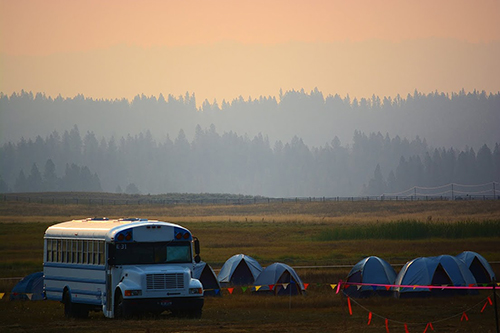
Smoke is one of the most prominent and visible aspects of biomass burning and has many impacts on the atmosphere. Smoke is comprised of gases and aerosols (particles suspended in the air). Aerosol particles are made of many materials including black carbon, brown carbon, organic carbon and mineral dust, each of which have unique and significant climate, health, and air quality impacts. Aerosols have the biggest impact on smoke optical properties, and evolve over time scales of seconds to days as they coagulate, dissipate, are diluted, and undergo chemical reactions in the atmosphere. Depending on the composition of the smoke, its altitude, and the humidity of the air supporting it, wildfire and agricultural burning smoke can either warm or cool the atmosphere. Smoke can contain ice and water-active particles that interact with clouds and affect visibility and air quality over global scales. Biomass burning is a singularly important source of brown carbon. However, the net direct climate-warming effect of all aerosol species generated by biomass burning, while highly uncertain, is currently believed to be small.
The optical properties of smoke determine the effects of smoke on visibility and climate, and also - critically - affect satellite detections of trace gases and aerosols. To the degree that FIREX-AQ determinations of smoke's properties can be linked more generally to smoke emissions globally, results from the campaign could help understand fires' wider impacts relevant to science questions #3 - 6.
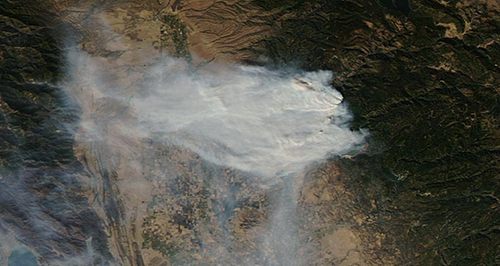
The impact of wildfires on regional- to global-scale atmospheric chemistry depends on the physical and chemical transformations that take place as fire emissions are transported, diluted, and exposed to reactive molecules, such as ozone. In addition, toxic gases and particulates that have health impacts can be both formed and destroyed. Due to their complexity, there is limited understanding of the factors that govern these processes, and individual fire plumes can have very different behaviors.
The physical and chemical processes governing the transformation of particles in biomass burning plumes is quite complex, with evidence for both loss and gain of particle mass. Mass can be lost as smoke is diluted, due to the evaporation of semi-volatile compounds. Reactions with oxygen in the air and of both gas- and particle-phase compounds from the smoke can lead to changes in both total particle mass and optical properties, with different chemistry active during the day and at night. The chemistry and surface coating properties of particles emitted by fires evolve as these physical and chemical changes take place, and affect the optical properties, cloud nucleation, and toxicological properties of the particles. The chemical transformation of fire-sourced pollutants is the main focus of science question #2.
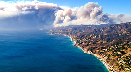
Plume injection height is the altitude range at which fire emissions are incorporated into the atmosphere. It is critical for forecasting smoke transport, lifetime, and chemistry, yet is still insufficiently modeled and understood.
By far the most common estimates of plume heights are based on satellite observations. Currently there are two satellite instruments that are capable of capturing plume injection height: the Multi-angle Imaging SpectroRadiometer (MISR) aboard NASA's Terra satellite; and the Cloud-Aerosol LIdar with Orthogonal Polarization (CALIOP) aboard NASA's CALIPSO satellite, a joint venture between NASA and the Centre National D'Etudes Spatiales. Both of these instruments provide essential and unique information. MISR has a greater ability to estimate near-fire plumes, and the MISR plume database is mature. However, MISR is on Terra with a morning overpass, while smoke plumes occur most often in the late afternoon. MISR also requires distinct smoke edges to estimate plume height. Some large smoke plumes can fill the MISR field of view such that a distinct smoke boundary cannot be observed. CALIOP, with its active LIDAR, provides superior plume height estimates; however, the field of view is limited to directly beneath the satellite, which is often far from the actual fire. Although these satellite measurements do provide valuable information on the statistics of injection heights, the connection to fire processes such as fuel, burning rate, etc. have not been sufficiently understood. Hence models generally attempt to use statistics-based estimates at injection heights that generate important uncertainties in smoke impacts.
Plume injection height will be directly observed during FIREX-AQ for a large number of fires and meteorological conditions, providing information relevant to science questions #2, 3, and 6.
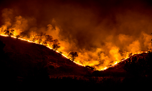
Wildfires have profound impacts on local and regional air quality due to their emission of primary and secondary particle pollution, their promotion of photochemical ozone production, and emission of toxic materials. These impacts are often the most immediate priority for consideration when making decisions on fire management, such as when to plan prescribed burns and when to allow naturally-initiated fires to burn. Advancing the research needed to understand and manage these impacts is one of the more challenging aspects of wildfire science, as it involves understanding small to medium scale processes detailed above: fire weather, emissions, and transport and transformation. This information must then be incorporated into models that can be used to make policy decisions on all timescales, from the immediate: e.g. fire management and health advisories, mid-term: air quality waiver, to the long-term: ecosystem and urban-wildland interface management. Meeting current National Ambient Air Quality Standards (NAAQS) for ozone and other criteria pollutants will require better understanding and prediction of fire impacts (along with long-range transport of pollution from other parts of the world).
Night-time plume evolution, air quality impacts, and exposure have not previously been studied in detail. Due to lower temperatures at nighttime the combustion efficiency of fires is generally lower than during the daytime, and as a result smoke does not get lifted as high at night. A common pattern for western wildfire smoke is to accumulate in valleys overnight, with fires only "blowing up" late in the afternoon or evening. Regions with concentrated smoke from these sudden low-altitude intensifications are often visible in satellite images close to the fires or hundreds of miles downwind of their source on subsequent days. Nighttime dilution and chemistry will play a role in both the local and downwind impacts of these plumes. The smoke that accumulates in valleys leads to impacts and high exposure closer to the sources. These varying scenarios need investigation with a combination of mobile laboratory and small aircraft platforms.
Night flights may be particularly useful in constraining emission factors for highly reactive gases that break down when exposed to sunlight during the day, but are longer-lived at night. Their short lifetimes make these compounds difficult to constrain from daytime observations despite their importance to understanding of fire plume photochemistry. Night-time fire plume sampling may serve to provide robust emission factors for such compounds.
The regional impacts and nighttime emission and chemical transformation of fires are the main focus of science question #3.
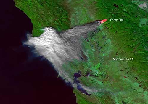
The climate impacts of wildfires are mostly associated with short-term forcers, like ozone and aerosols including black carbon, brown carbon and organic carbon. Global climate impacts of biomass burning result from its truly massive contributions to aerosol optical depth over large areas. Aerosol optical depth refers to the amount of aerosols, or particles such as urban haze, smoke, desert dust or sea salt, distributed within a column of air from the Earth's surface to the top of the atmosphere.
Regions such as the Arctic and the cloud decks of South America are uniquely sensitive to biomass burning emissions and to secondary processes, such as cloud and ice nucleation, that can magnify the radiative impact of the emissions. The research needed to advance our understanding of these impacts is broad on both spatial and temporal scales, and relates to a wide spectrum including biomass burning inventories, satellite fire detection, chemical evolution of gaseous species, aerosol microphysical and optical properties, proper integration into models, interactions with warm, mixed phase, and ice clouds, and effects on the vertical structure of the thermal profile.
Current fire emissions inventories undercount small fires and domestic biomass burning because they are based on satellite fire-detection methods that have limited resolution. Therefore, regional airborne measurements of fire products, like those that will be captured during FIREX-AQ, are invaluable in assessing inventories. Improving the integration of wildfires and biomass burning into global models requires more detailed emission estimates at finer spatial scales and better understanding of how to represent these emissions in relatively coarse-resolution treatment after significant chemical processing and dilution. These efforts will require combining new chemical details from emission measurements, new insights about chemical and physical transformation of smoke, supported by observations from the next generation of satellites.
The global impacts and climate relevant properties of fires are the main focus of science questions #4 and #5.