A .gov website belongs to an official government organization in the United States.
Secure .gov websites use HTTPS
A lock () or https:// means you've safely connected to the .gov website. Share sensitive information only on official, secure websites.
Platform: AERONET
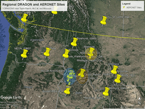
There are 9 permanent northwest regional sites plus 2 campaign sites in the U.S.
The AERONET program is a federation of ground-based remote sensing aerosol networks established by NASA and LOA-PHOTONS (CNRS) and has been expanded by collaborators from international agencies, institutes, universities, individual scientists and partners. AERONET (AErosol RObotic NETwork) provides a long-term, continuous public database of aerosol optical, microphysical, and radiative properties for aerosol research and characterization, validation of satellite measurements, and synergism with other databases.
Researchers from NASA Goddard Space Flight Center deploy AERONET stations for FIREX-AQ – Distributed Regional Aerosol Gridded Observation Networks (DRAGON) of 5 or more cimels distributed horizontally and vertically – at fixed locations in Missoula, Taylor Ranch and McCall. In addition two mobile deployment teams manage regional platforms with lidar and sun photometer.
Additional contributions:
Moveable DRAGON: 3-6 fire chasers semi-mobile sun photometer sites w/solar and lunar AOD (aerosol optical depth)
Multiple microtops sun photometers
Base of operations in McCall: polar Cimel, Micro Pulse mini LiDAR, PANDORA spectrometer, Filters
NRT AOD (near real-time aerosol optical depth) for most AERONET sites; Daily Summary of all sites
Communication via cell phone, Iridiam phone and coordination w/BY and JD at Boise
Regional DRAGON and AERONET sites operate 22 July - 6 September with night focus 7 - 21 August for FIREX-AQ.