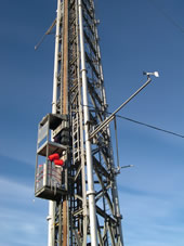
Boulder Atmospheric Observatory 2008 PSD Wind Profilers / Met Station
A network of 3 radar wind profilers operated by NOAA ESRL Physical Sciences Division will be deployed in the Front Range along an approximate East-West line. A surface meteorological measurement station will be located on the Continental Divide. The aim is to observe the growth of planetary boundary layer and cross-Divide transport.
Measurement Period: July - August 2008
Contact: Allen White 303-497-5155
Data Download
Data description:
| Locations | Coordinates | Elev (m) | Instruments | Measurement |
|---|---|---|---|---|
| Erie | 40.100 N, 105.040 W | 1530 | Radar wind profiler | Vertical profiles of horizontal winds |
| Table Mountain | 40.128 N, 105.244 W | 1709 | Radar wind profiler | Vertical profiles of horizontal winds |
| Granby Airport | 40.089 N, 105.917 W | 2504 | Radar wind profiler | Vertical profiles of horizontal winds |
| Continental Divide | 39.887 N, 105.698 W | 3697 | Surface met station | Standard meteorological data |

